Everest Three Passes Trek Map: Route Explanation
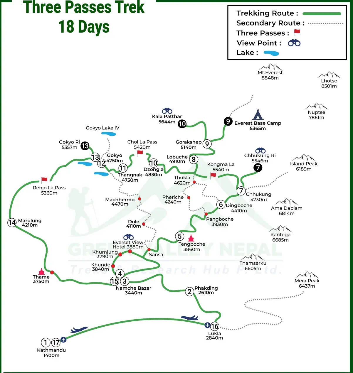
Lukla to Namche Bazaar
The trek begins at Lukla’s Tenzing-Hillary Airport (2,860m) in the lower part of the map and follows the Dudh Koshi River valley northward. The route passes through Phakding (2,610m) before making a major ascent to Namche Bazaar (3,440m), with a net elevation gain of about 580 meters over two days.
This section of the map shows a clear northeast trail direction and a relatively straightforward climb through the lower Khumbu, which serves as the main entry corridor into the region.
Namche Bazaar’s location at a junction of multiple trails highlights its strategic role as a key acclimatization base and gateway before continuing toward the higher elevations of the three-pass circuit.
Namche Bazaar to Dingboche and Chhukung
Moving northeast from Namche Bazaar, the map shows the trail dividing into two main routes. The standard Everest Base Camp trail continues toward Tengboche, while the Three Passes Trek follows the eastern route through Pangboche to reach Dingboche (4,410m).
This section represents the transition into true high-altitude terrain, with the map highlighting an elevation gain of nearly 1,000 meters from Namche to Dingboche over 2–3 trekking days.
Dingboche is shown in a central position within the Imja Khola valley, set below major peaks such as Ama Dablam and Lhotse. From Dingboche, the map also marks a side trail heading east to Chhukung (4,730m), located near Island Peak and the approach to Kongma La Pass, with Chhukung appearing as a small but significant high-altitude settlement in the upper Imja valley.
Crossing Kongma La Pass (5,535m)
Kongma La Pass, the highest of the three passes, is usually crossed first when trekking the circuit clockwise. On the map, it lies southeast of Gorak Shep and directly links the Chhukung area with the Everest Base Camp section.
The pass connects the Imja Khola valley in the east to the Khumbu valley in the west, a strategic position that explains why most trekkers begin with this crossing due to its proximity to Chhukung and natural progression toward Everest Base Camp.
The route map highlights a challenging ascent from Chhukung across boulder fields and glacial moraine to the prayer-flag-marked summit, followed by a steeper descent toward the Khumbu Glacier near Lobuche (4,940m), with cairns shown along the rocky and exposed trail.
Everest Base Camp and Kala Patthar Section
This part of the route appears on the map as a northern extension branching from the main Everest Three Passes Trek near Lobuche. It leads to Gorak Shep (5,164m), which functions as the base for visiting both Everest Base Camp (5,364m) and Kala Patthar (5,644m).
The map places Everest Base Camp north of Gorak Shep at the base of the Khumbu Icefall, connected by a glacier route along the Khumbu Glacier, while Kala Patthar is shown southwest of Gorak Shep as a key viewpoint.
After completing these side trips, the map shows trekkers rejoining the main circuit at Dzongla (4,830m), west of Lobuche, forming a westward link that prepares for the Cho La Pass crossing. Although shown as a detour, this section is a core part of most Three Passes itineraries and adds substantial value to the trek.
Crossing Cho La Pass (5,420m)
Cho La Pass is shown on the map in the western section of the Everest Three Passes Trek, forming the crucial link between the Everest Base Camp area and the Gokyo Valley. It connects Dzongla on the eastern side with Dragnag (4,700m) on the western approach to Gokyo.
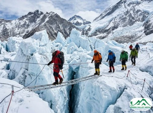
The map highlights why Cho La is considered the most technically challenging pass, as the route crosses the Cho La Glacier, a section often marked as hazardous, especially in winter or early trekking seasons due to snow and ice.
Route maps typically emphasize the glacier crossing before the steep climb to the pass, while the western descent toward Gokyo is shown as less steep but still challenging, involving loose scree and boulder fields.
The map also clearly illustrates the shift in valley orientation from the south–north Khumbu valley to the north–south Gokyo valley system.
Gokyo Valley and Gokyo Ri
The Gokyo Lakes, shown on the western section of the Three Passes map, form a chain of six turquoise glacial lakes. The main settlement, Gokyo (4,790m), lies beside the third lake, Dudh Pokhari, roughly halfway up the valley.
Gokyo Ri (5,357m) is prominently marked north of the village as a key viewpoint, accessible from the settlement and offering panoramic views of Everest, Lhotse, Makalu, and Cho Oyu.
The map also shows the fourth, fifth, and sixth lakes extending north toward the Ngozumpa Glacier, the Himalayas’ longest glacier, with optional viewpoints like Scoundrel’s Viewpoint marked for trekkers seeking further exploration beyond Gokyo Ri.
Crossing Renjo La Pass (5,464m)
Renjo La Pass, shown on the map as the northernmost and final pass of the Everest Three Passes Trek, lies west of Gokyo and links the Gokyo Valley with Lungden (4,380m) and Thame (3,800m) in the Bhote Koshi valley.
From Gokyo, the trail heads north-northwest, ascending to the pass along the ridge separating these valleys, marking the circuit’s closure.
The descent toward Thame is highlighted on the map as a scenic, winding route dropping nearly 1,700 meters in a day, passing through Lungden and following the Bhote Koshi River valley.
Topographical maps show this section as more vegetated compared to the barren high passes, signaling the return below the tree line to lower elevations.
Return Route to Lukla
The final section of the map depicts the return from Thame to Lukla, completing the circuit loop. From Thame, the trail heads west to reconnect with the main Everest trekking routes at Namche Bazaar, forming a clearly marked junction.
This Thame-to-Namche segment follows a well-established western valley route, taking about 3–4 hours, and returns trekkers to the point where they initially branched toward the higher circuit.
From Namche, the descent retraces the original path along the Dudh Koshi River valley back to Lukla, dropping approximately 580 meters over one to two days and passing through villages such as Phakding and Tok Tok, providing a familiar conclusion to the circular journey through the Khumbu region.
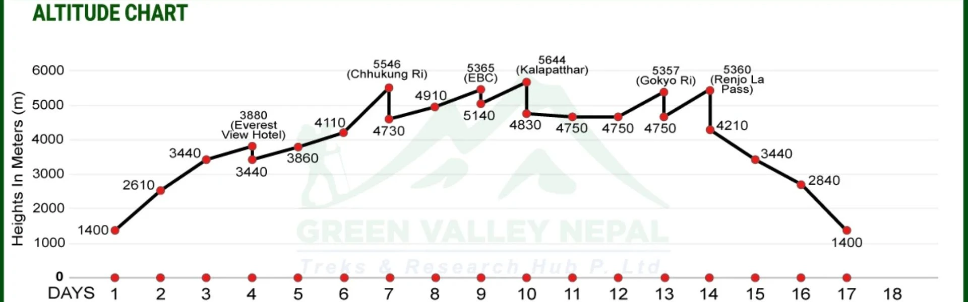
Everest Three Passes Trek Altitude Chart
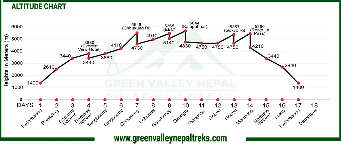
The trek begins at Lukla’s Tenzing-Hillary Airport (2,860m), already high enough to expose trekkers to reduced oxygen levels. Most trekkers fly directly from Kathmandu (1,400m), gaining about 1,460 meters in 30–35 minutes, making gradual trekking in the first days essential for acclimatization. Lukla serves as the baseline for all subsequent elevation measurements, and some visitors may feel mild altitude effects even at this starting height.
Gradual Ascent vs Sharp Altitude Gains
Gradual Sections:
- Lukla to Namche Bazaar: +580m over 2 days (2,860m → 3,440m).
- Namche to Tengboche and onward to Dingboche: daily gains of 400–550m.
- Return from Thame to Namche and Lukla: gentle descent, allowing recovery.
Sharp Gains (Pass/Peak Days):
- Kongma La Pass: Chhukung (4,730m) → 5,535m (+805m) → descent to Lobuche (4,940m).
- Kala Patthar: Gorak Shep (5,164m) → 5,644m (+480m).
- Cho La Pass: Dzongla (4,830m) → 5,420m (+590m).
- Renjo La Pass: Gokyo (4,790m) → 5,464m (+674m).
These sharp gains occur at already high altitudes with lower oxygen, testing both physical and mental endurance.
Highest Trekking Points vs Sleeping Points
- Highest Trekking Points: Kala Patthar (5,644m) is the highest, followed by Kongma La (5,535m) and Everest Base Camp (5,364m). The three passes themselves are all traversed during the day, not overnight.
- Highest Sleeping Points: Gorak Shep (5,164m) is the highest overnight stay, followed by Lobuche (4,940m), Chhukung (4,730m), Gokyo (4,790m), and Dzongla (4,830m). Sleep points form plateaus in the altitude chart, allowing adaptation. Trekking vs sleeping altitude differences of 400–700m follow the “climb high, sleep low” principle.
Essential Acclimatization Days
- Namche Bazaar (3,440m): First critical rest day (usually day 3). Trekkers hike to Everest View Hotel (3,880m) or Khumjung/Khunde (3,790m) and return to sleep at Namche.
- Dingboche (4,410m): Second major acclimatization point (day 6–7). Hikes may include Nagarjun Hill (5,100m) or Chhukung Ri (5,546m) before returning to Dingboche to prepare for Kongma La.
- Gokyo (4,790m): Recommended rest before Renjo La, with possible Gokyo Ri (5,357m) hike.
- Pheriche (4,371m): Alternative to Dingboche for a second rest day, with similar altitude benefits.
Conclusion
The Everest Three Passes Trek map and altitude chart are essential for safe and confident trekking. They guide independent trekkers through route-finding and decision-making, help guide trekkers engage with the journey, and allow experienced mountaineers to plan optimized itineraries.
The map shows the geographical flow from Lukla through the three passes: Kongma La (5,535 m), Cho La (5,420 m), and Renjo La (5,464 m), while the altitude chart highlights critical acclimatization points and the most demanding sections above 5,400 m.
Key locations, from Namche Bazaar to Dzongla, provide practical infrastructure and strategic rest points. Understanding the map before departure enables trekkers to navigate safely, make informed altitude and route decisions, and fully enjoy the challenges and rewards of this iconic high-altitude circuit.
Frequently Asked Questions (FAQs)
- What does the Everest Three Passes Trek map show?
The Everest Three Passes Trek map shows the complete loop route starting and ending at Lukla, including the three high passes: Kongma La, Cho La, and Renjo La. It highlights major villages, acclimatization points, valleys, side routes to Everest Base Camp and Kala Patthar, and overall elevation changes along the trek.
- Where does the Everest Three Passes Trek start and end on the map?
On the map, the Everest Three Passes Trek starts and ends at Lukla. The route forms a circuit through the Khumbu, Imja, and Gokyo valleys before returning to Lukla via Thame and Namche Bazaar.
- Which pass comes first on the Everest Three Passes Trek map?
According to the standard Everest Three Passes Trek map, Kongma La Pass is crossed first, followed by Cho La Pass, and finally Renjo La Pass. This sequence allows for better acclimatization and a more gradual altitude gain.
- Does the Everest Three Passes Trek map include Everest Base Camp?
Yes, the Everest Three Passes Trek map includes a side route to Everest Base Camp and Kala Patthar. These sections branch off the main circuit near Lobuche and Gorak Shep before rejoining the primary route.
- How does the altitude chart help in understanding the Three Passes Trek?
The altitude chart helps trekkers visualize elevation gains and losses throughout the trek. It shows where the trail climbs sharply, where acclimatization days are needed, and how altitude changes around each high pass, making planning safer and more efficient.
- Is the Everest Three Passes Trek map suitable for independent trekkers?
Yes, the Everest Three Passes Trek map is very useful for independent trekkers. It provides clear route orientation, identifies key villages and high passes, and helps with daily distance and altitude planning, especially in remote sections of the trek.
- How is the Everest Three Passes Trek map different from an Everest Base Camp map?
The Everest Three Passes Trek map is more complex than an Everest Base Camp map. It covers multiple valleys, three high-altitude passes above 5,300 meters, and longer trekking days, whereas the Everest Base Camp map follows a single main trail with fewer elevation changes.
- Is the Everest Three Passes Trek map useful during bad weather?
Yes, the Everest Three Passes Trek map is especially useful during bad weather, as it helps trekkers confirm their position, identify nearby villages, and make safer route decisions when visibility is limited.
- Do I need a GPS track if I already have the Everest Three Passes Trek map?
A detailed Everest Three Passes Trek map is sufficient for route understanding, but many trekkers prefer using a GPS track alongside the map for added navigation accuracy, especially when crossing high passes or glaciers.
- Is it common for trekkers to get lost even with a map on the Three Passes Trek?
Most backpackers do not get lost using offline GPS and trekking apps, but the glacier and pass approaches can be confusing during snow or bad weather. A plain paper map may not be reliable alone in those conditions.
- How accurate are map routes in the high pass sections like Kongma La, Cho La, and Renjo La?
While general trails are clear where the trek overlaps with EBC and other main trails, the glacier and high pass areas are not always obvious and may not show perfectly on basic maps. Downloading GPX tracks and offline maps like Maps.me, Gaia GPS, and AllTrails can help in those sections.