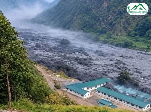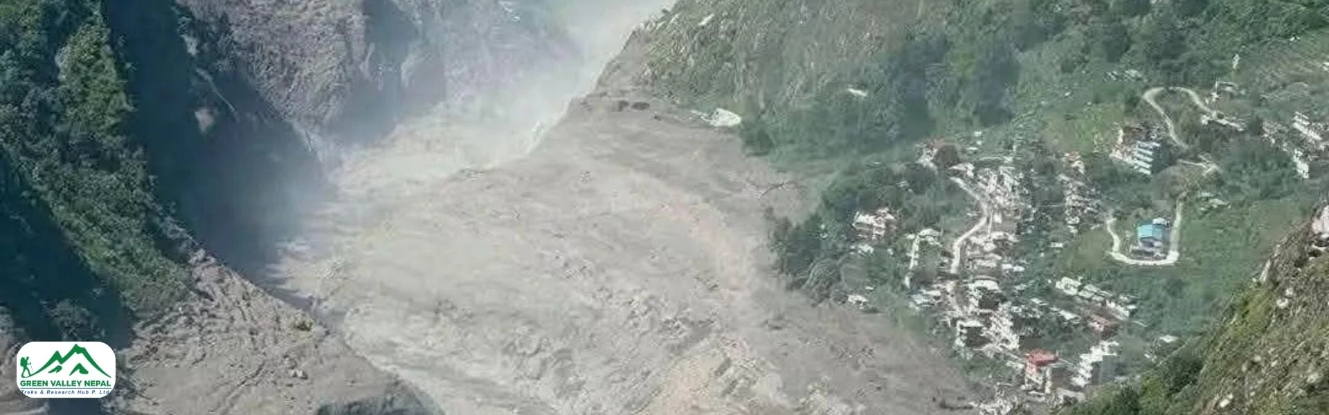
A sudden and powerful flash flood tore through the Bhotekoshi River in Rasuwa district on the morning of August 26, 2026, causing major destruction in Syabrubesi and Timure, two of the most important settlements along the Kathmandu-to-Kerung (Rasuwagadhi) trade and trekking corridor. Below is a fact-based roundup of what happened, why it happened, how the government has responded, and what it means for travelers and trekkers heading toward the Langtang region.
Bhotekoshi Flood in Rasuwa, Nepal: Causes, Damage & Updates 2026
Table of Contents
What Happened: Timeline of the Bhotekoshi Flood
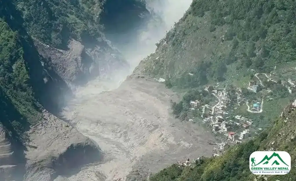
According to Rasuwa's Chief District Officer, Narendra Pariyar, the flood struck without warning at around 9:15 a.m. on Wednesday, coming down from the Tibetan side of the border. Residents in riverside settlements reported that water entered their communities almost instantly, leaving people very little time to react. Tibetan authorities on the other side of the border had reportedly alerted Rasuwa's police administration earlier that morning after the flood was first observed upstream, according to Nepal News.
Some reports citing Nepal's flood forecasting division noted that the surge reached water levels roughly 100 meters above the river's normal surface near the point of impact, an indication of just how forceful the initial wave was, a detail reported by Radio Nepal Online. The flood then travelled downstream through the Bhotekoshi and into the Trishuli River system, with visible impacts later reported as far as Trishuli Bazaar and the Devighat area in Nuwakot.
Areas Affected: Syabrubesi, Timure and the Trishuli Corridor
The worst-hit areas so far are:
- Timure: A border town near the Rasuwagadhi customs point, where the flood caused major damage to the customs office and nearby structures.
- Syabrubesi: The main gateway town for the Langtang trekking region, which also suffered significant structural damage.
- Rasuwagadhi Rural Municipality: Local authorities said several homes may have been swept away, though many residents reportedly reached higher ground in time.
- Trishuli Bazaar and Devighat (Nuwakot): Downstream areas that felt the impact as the floodwater moved along the Trishuli River.
According to updated local reporting from Nepal News English, roughly 60 houses and two bridges were swept away by the flood across the affected areas, and public transport between Kathmandu and seven districts along the route was suspended as a precaution. Communication infrastructure was also hit hard; several telecom towers in Rasuwa and Nuwakot were reportedly damaged, disrupting mobile networks in the region at a time when clear communication is critical for rescue coordination.
Authorities have also confirmed that several armed police personnel posted at a border outpost (BOP) near Timure went out of contact after the flood, and search efforts for them are ongoing alongside the broader rescue operation. The historic settlement of Betrabati was also reportedly swept through by the floodwaters, and specific municipal wards, including Gosaikunda Rural Municipality-2 and Ward No. 5 of Syabrubesi, have been named by officials as areas with confirmed structural damage.
What Caused the Flood: Glacial Lake Outburst Flood (GLOF) Suspected
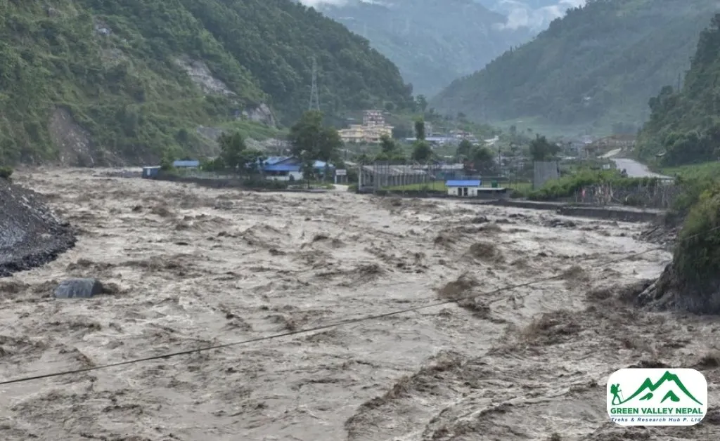
Nepal's Department of Hydrology and Meteorology (DHM) says the flood is very unlikely to have been caused by rainfall. Weather stations in Kyangjin and Dhunche, close to the Nepal–China border, recorded little to no precipitation around the time of the surge, and CDO Narendra Pariyar himself noted that there had been no significant rainfall on the Nepali side of the river basin, according to Peoples' Review.
Because the Bhotekoshi's Tibetan catchment holds numerous glaciers, hydrologists' current working theory is that the disaster was triggered by a Glacial Lake Outburst Flood (GLOF), the sudden failure of a natural ice or moraine dam holding back a glacial lake, releasing a huge volume of water and debris in a matter of minutes.
Binod Parajuli, Chief of Nepal's Flood Forecasting Section, said the flood's sudden arrival, without any corresponding rainfall, points strongly toward a glacial-origin event rather than a monsoon-driven flood. The DHM has requested emergency satellite imagery through the Sentinel Asia platform and is coordinating with Chinese authorities across the border to confirm exactly where and how the lake failure occurred. As of this writing, the GLOF theory remains the leading explanation but has not been formally confirmed with satellite evidence; see The Himalayan Times' coverage of the ongoing investigation.
It's worth noting that GLOFs are becoming a recognized pattern in this exact river system; see the "Has This Happened Before?" section below for important context.
Infrastructure and Economic Damage
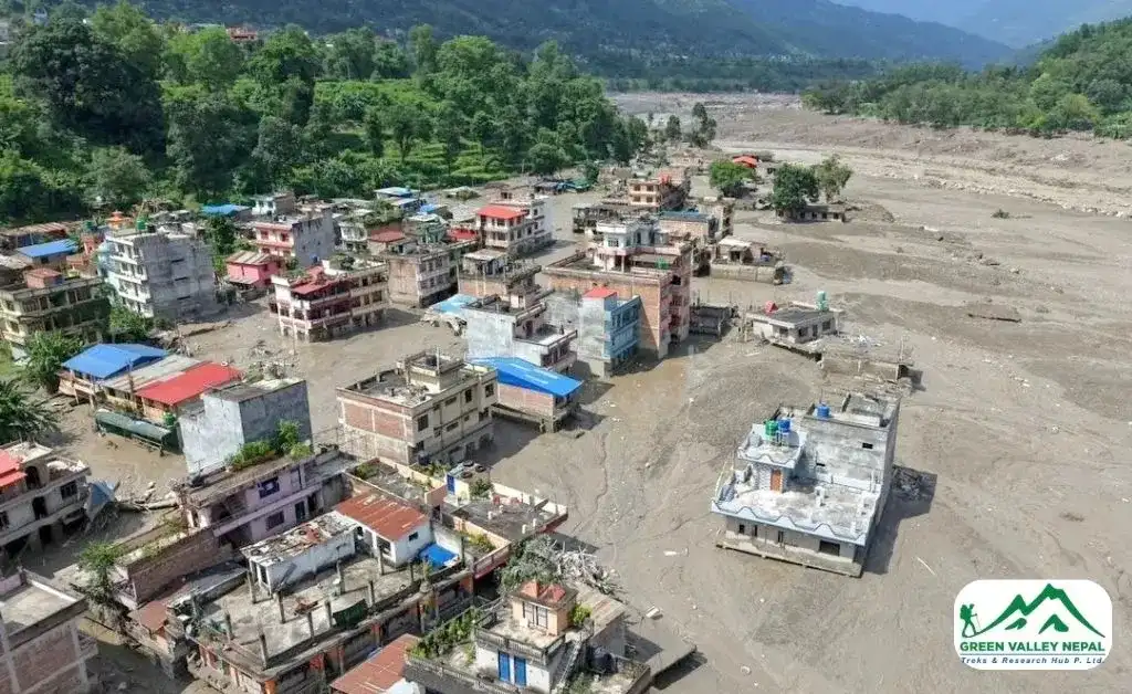
Beyond homes and roads, the flood has hit the region's energy and trade infrastructure hard:
- Hydropower projects damaged or halted: According to the Independent Power Producers' Association, Nepal (IPPAN), as reported by Everest Chronicle, more than ten hydropower projects along the Bhotekoshi and Trishuli rivers have been affected, with production halted at several facilities, including the 111 MW Rasuwagadhi Hydropower Project, the Chilime Hydropower Project, and Trishuli 3A. Some smaller riverside plants are reported to have been swept away entirely, a loss also confirmed by The Kathmandu Post.
- Bridges and roads: At least two bridges were destroyed, and the Pasang Lhamu Highway, the main road connecting Kathmandu to Rasuwa and the Langtang region, has seen sections of vehicle traffic suspended for safety.
- Cross-border trade disrupted: The Rasuwagadhi/Timure border point, a key overland trade route with China, has been disrupted, with the customs office itself damaged. This is a particular concern with the Dashain festival season approaching, when import volumes typically rise, per Everest Chronicle's report.
- Downstream alert zone expanded: As the surge moved down the Trishuli River, high-alert warnings were extended well beyond Rasuwa to Nuwakot, Dhading, Gorkha, Chitwan, and reportedly as far downstream as Muglin and Narayanghat.
Government Response and Rescue Operations
The scale of the damage prompted an immediate, high-level response from Kathmandu:
- Prime Minister Balendra Shah confirmed that the Nepali Army, Armed Police Force, and Nepal Police have all been mobilized for search, rescue, and relief work, with additional security personnel dispatched from neighboring districts.
- The National Disaster Risk Reduction and Management Authority has been activated, coordinating with medical teams, the Scouts, and the Red Cross.
- All helicopters (government and private) have been put on standby, and multiple Nepali Army helicopters carrying health workers have already been deployed to the affected area for search and evacuation support.
- The government has directed Chief District Officers in at-risk downstream districts to relocate residents from vulnerable riverbank areas immediately, using SMS alerts and phone calls to warn communities in Rasuwa, Nuwakot, Dhading, Gorkha, and Chitwan.
- Minister for Communications and Information Technology, Dr. Bikram Timilsina, has urged people living near rivers and landslide-prone zones to avoid unnecessary travel and to rely only on official information rather than rumors, given that the situation is still developing.
- A dedicated hotline (1234) has been made available for people seeking relief information or updates on missing family members.
- Senior ministers, including Finance Minister Dr. Swarnim Wagle and top customs officials, have been personally coordinating rescue logistics around the Timure customs point, an important trade checkpoint on the Nepal–China border, per Nepal News.
- Opposition leaders, including Nepali Congress's Dr. Shekhar Koirala and UML chair KP Sharma Oli, have publicly called for rescue and relief work to proceed on a war footing, with Oli specifically urging UML cadres and volunteers to join relief efforts on the ground.
Damage Assessment: Still Unfolding
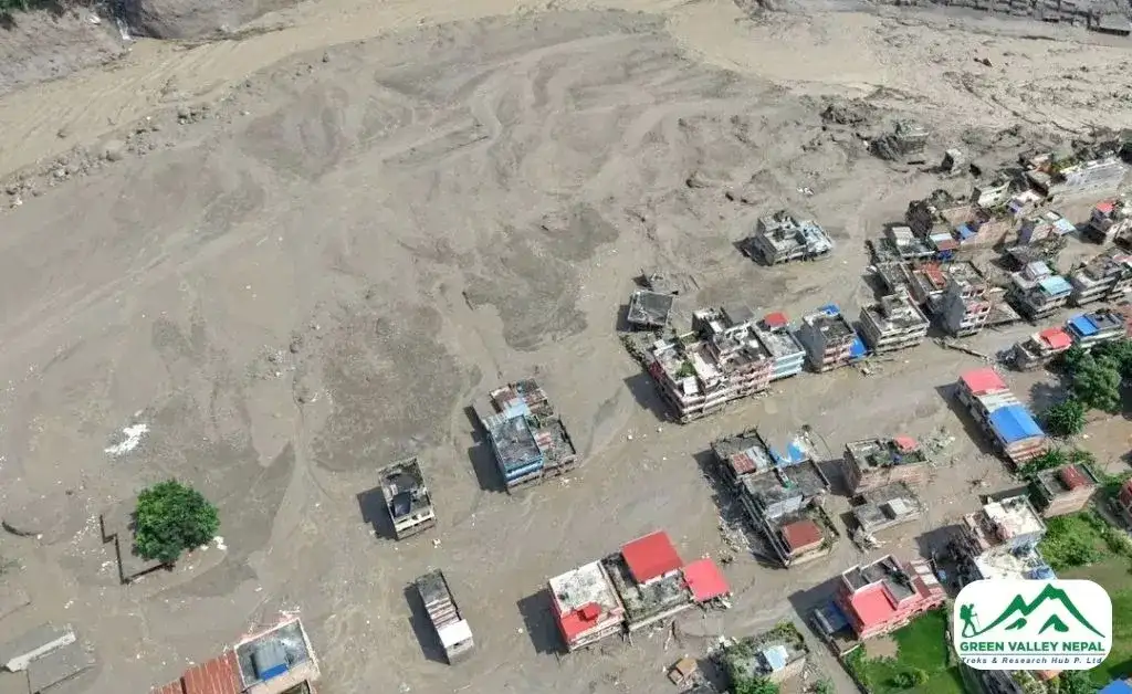
Officials have been candid that a complete and verified damage report will take time. CDO Pariyar himself noted that it was not yet possible to state the exact extent of the damage in the immediate aftermath, as teams were still trying to establish the full picture.
Local elected representatives in the affected municipalities have echoed this, saying the situation on the ground currently makes it difficult to even begin a formal loss assessment. What is confirmed so far includes damaged homes, a disrupted customs facility in Timure, multiple downed telecom towers, and possible casualties or missing persons among both civilians and security personnel, figures that are expected to be updated as rescue teams reach cut-off areas.
Why This Matters for Trekkers and Travelers?
Syabrubesi is the standard starting point for the Langtang Valley, Tamang Heritage, and Ganja La treks, and Timure sits along the road that connects Kathmandu to the Rasuwagadhi border crossing with Tibet. Reports indicate that thousands of trekkers were on the Langtang route at the time of the flood, including many heading toward Gosaikunda, one of the region's most popular high-altitude lake destinations. This flood has directly affected the road and settlement infrastructure trekkers and trans-border travelers rely on. Key points for anyone with travel plans in the region:
- Highways affected: Vehicle movement has been suspended on sections of the Prithvi Highway and the Pasang Lhamu Highway (the main route toward Rasuwa and the Langtang region), and public transport between Kathmandu and seven affected districts has been halted as a precaution.
- Riverside trails and campsites at risk: Authorities have asked people to stay away from riverbanks throughout Rasuwa, Nuwakot, Dhading, Gorkha, and even Chitwan, as the flood risk is still considered active downstream.
- Communication gaps: With several telecom towers down, travelers already in the region may be temporarily unreachable; this is not necessarily a cause for alarm, but families should expect delays in contact.
- Trekking permits and route access: Anyone with upcoming Langtang-region treks should check directly with their operator before departure, as trail conditions, bridges, and teahouse infrastructure near Syabrubesi may need inspection and repair before it's safe to proceed.
If you're planning a trek in this region in the coming weeks, it's worth confirming current trail conditions with a locally registered operator rather than relying on older guidebooks or maps, since infrastructure along this corridor is actively changing in the flood's aftermath.
Has This Happened Before? A Recurring Risk on the Bhotekoshi
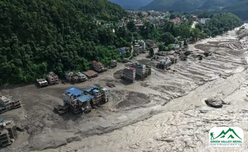
This is not the first time this exact river system has flooded catastrophically. On July 8, 2025, just over a year before this incident, a similar flash flood originating from Tibet's Lhende River surged into the Bhotekoshi, killing at least nine people and leaving 19 missing, including Nepali customs staff, police personnel, and Chinese nationals. That flood swept away the Miteri Bridge linking Nepal and China, damaged the Rasuwagadhi dry port, destroyed hydropower infrastructure, and severely damaged the Syabrubesi to Rasuwagadhi road. Investigators later attributed the event to a supraglacial lake outburst on a Tibetan glacier near the Lhende River headwaters, a finding also documented on Wikipedia's overview of the 2025 Nepal floods.
The recurrence of two major glacial-origin floods in this same river corridor within about 13 months has drawn attention from regional climate researchers. The International Centre for Integrated Mountain Development (ICIMOD) has flagged glacial lake outburst floods as a growing hazard across the Hindu Kush–Himalaya region, warning that many of the lakes responsible are newly formed, small, or previously undocumented, meaning they weren't on any hazard map before they burst, a pattern also seen in the 2024 Thame flood in the Everest region. This makes the Bhotekoshi/Rasuwagadhi corridor one of the more closely watched flood-risk zones in Nepal going forward.
Safety Reminders for Residents and Visitors
- Avoid riverbanks and low-lying areas near the Bhotekoshi and Trishuli rivers until authorities confirm the water level has stabilized.
- Do not attempt unnecessary travel through the affected corridor.
- Rely on official channels, such as the National Disaster Risk Reduction and Management Authority (NDRRMA) and Nepal Police, for updates rather than unverified social media posts.
- If you have family or contacts in the affected area and cannot reach them by phone, contact Nepal's disaster relief hotline (1234) or local security agencies for the latest rescue updates rather than assuming the worst; network outages are affecting many areas independent of casualties.
Final Thoughts
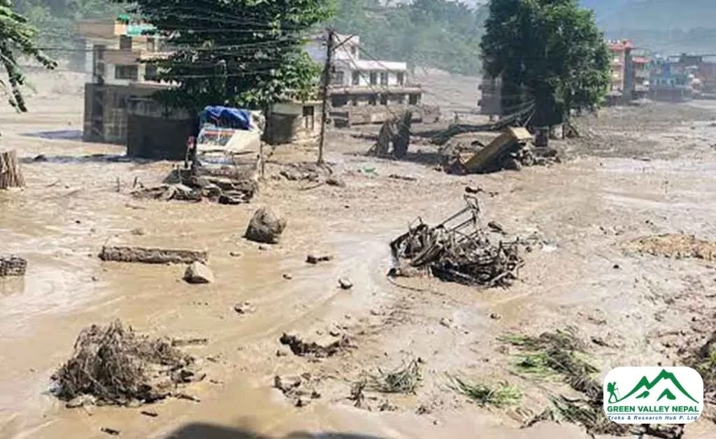
The Bhotekoshi flood is a stark reminder of how quickly conditions can change in Nepal's high mountain river systems, especially where Transboundary Rivers originate in Tibet's glacial and monsoon-fed catchments. Rescue and relief operations are moving quickly, with the army, police, and helicopters actively working across Rasuwa and Nuwakot. We'll continue to monitor official updates and will revise this post as more verified information about casualties, damage, and road/trail reopening becomes available.
Frequently Asked Questions (FAQs)
- What caused the Bhotekoshi flood in Rasuwa?
Hydrologists suspect a Glacial Lake Outburst Flood (GLOF) in Tibet, not rainfall. Weather stations near the Nepal–China border recorded little to no rain at the time, so Nepal's Department of Hydrology and Meteorology believes a glacial lake upstream in Tibet likely burst suddenly, sending a large volume of water and debris down the Bhotekoshi River. Nepali authorities are coordinating with China and using satellite imagery to confirm the exact cause.
- Which areas in Nepal were most affected by the flood?
The worst-hit areas are Timure and Syabrubesi in Rasuwa district, including the Timure Customs Office, Gosaikunda Rural Municipality-2, and Ward No. 5 of Syabrubesi. The flood also affected Betrabati and travelled downstream into the Trishuli River, prompting alerts as far as Trishuli Bazaar, Devighat, Muglin, and Narayanghat in Nuwakot, Dhading, Gorkha, and Chitwan districts.
- Is it safe to trek in the Langtang region right now?
Not immediately; trail and road infrastructure near Syabrubesi has been damaged, and highways including the Pasang Lhamu Highway have seen sections closed. If you have an upcoming Langtang, Gosaikunda, or Tamang Heritage trek booked, check directly with a registered trekking operator for the latest route and safety updates before departure, since conditions are changing quickly.
- How many houses and how much infrastructure were damaged?
Early estimates put the toll at around 60 houses and at least two bridges swept away, with more than ten hydropower projects affected, including the 111 MW Rasuwagadhi, Chilime, and Trishuli 3A plants. Several telecom towers were also damaged, and the full damage assessment is still ongoing.
- Has a flood like this happened in Rasuwa before?
Yes. On July 8, 2025, a similar GLOF-triggered flood struck the same Bhotekoshi corridor, killing at least nine people, leaving 19 missing, and destroying the Miteri Bridge and other infrastructure. Two major glacial-origin floods hitting this same river system within about 13 months have raised concern among climate and disaster-risk experts about the growing frequency of GLOFs in this part of the Himalaya.

Arjun Pandey
Call us on WhatsApp+977 9841 392186OrChat with us