Embark on a journey of Everest Gokyo Trek via Salleri that promises not only breathtaking landscapes but also a truly distinct experience that sets this trek apart. Imagine walking through pristine trails, surrounded by the untouched beauty of the Himalayas. This route, less traveled yet equally awe-inspiring, offers you a chance to explore hidden gems while indulging in the thrill of trekking.
Everest Gokyo Trek via Salleri Route Map and Altitude Chart
Table of Contents
Everest Gokyo Trek via Salleri Route Map

What makes the Everest Gokyo Trek via Salleri adventure even more exciting is the Everest Gokyo Trek via Salleri Route Map. This map serves as your ultimate guide, leading you through the enchanting terrains with precision. As you make your way to the heart of the Gokyo region, this comprehensive map becomes your compass, ensuring you stay on the right path. With its intricate details, trail markings, and prominent landmarks, the map not only adds a layer of assurance but also enhances the overall experience.
Trekking through the Everest Gokyo region via Salleri is an experience like no other, and the route map becomes your trusted companion, opening doors to discovery and wonder. It offers not just directions but also insights into the rich tapestry of nature, culture, and adventure that awaits you. So, lace up your boots and embrace the journey, armed with the Everest Gokyo Trek via Salleri Route Map to guide you every step of the way.
Importance of Everest Gokyo Trek via Salleri Route Map
Everest Gokyo Trek via Salleri Route Map emerges as an indispensable tool, bridging the gap between aspiration and realization. When trekking through remote and awe-inspiring regions like Everest Gokyo via Salleri, having a reliable guide becomes paramount, and that guide takes the form of a comprehensive route map.
Trekking is a harmonious blend of exploration and navigation. In regions where trails wind through rugged terrain and landscapes remain uncharted, a route map becomes the compass that points trekkers in the right direction. It's not merely a piece of paper; it's a lifeline that ensures you stay on course, making each step deliberate and secure.
Imagine the solitude of the Himalayan trails, where cell signals may falter and landmarks might be elusive. Here, the Everest Gokyo Trek via Salleri Route Map becomes your unwavering companion, providing clarity and direction in the midst of nature's grandeur. It offers more than just coordinates; it unveils a sense of orientation, guiding you through the twists and turns of the journey.
But it doesn't stop at navigation alone. This map is a gateway to effective planning, allowing trekkers to anticipate challenges, allocate resources, and strategize rest stops. It transforms the trek into a meticulously orchestrated adventure, where every decision aligns with your ultimate goal – reaching the Gokyo region in all its splendor.
Exploring the Everest Gokyo Trek via Salleri Route Map

Everest Gokyo Trek via Salleri is a venture into the heart of the Himalayas, where every step brings you closer to nature's grandeur. Amidst this captivating journey, the Everest Gokyo Trek via Salleri Route Map emerges as your unwavering guide, a vital companion that enriches your exploration in ways beyond imagination.
Imagine unfolding a piece of paper that unveils not just lines and symbols, but a pathway to discovery. The Everest Gokyo Trek via Salleri Route Map is precisely that – an invaluable tool that transforms a challenging expedition into a curated experience. Its meticulously designed features provide trekkers with a treasure trove of information, ensuring you stay connected to the journey while staying on track.
This map isn't merely a visual guide; it's a key to understanding the terrain. The intricate trail markings depict the winding paths, river crossings, and elevation changes that define the trek. Topography comes alive through contour lines, allowing you to anticipate ascents and descents, thus pacing yourself for the journey ahead.
But it doesn't stop there. Landmarks, those invaluable points of reference, are etched onto the map like signposts of discovery. The revered Namche Bazaar, and the serene Gokyo Lakes – these icons are brought to life, inviting you to immerse in their magnificence.
And in the realm of adventure, flexibility is essential. Here, the Everest Gokyo Trek via Salleri Route Map shines, offering alternate routes that empower you to tailor your journey. Whether you choose the road less taken or the well-trodden path, the map ensures you're in control of your experience.
Perhaps the most remarkable facet of this map is its ability to enhance the trekking experience itself. As you trace the lines and follow the markers, the path unfolds before your eyes. The map empowers you with a clear visualization of what lies ahead, be it a thrilling ascent or a serene lakeside retreat. It deepens your connection to the landscape, amplifying the wonder of each step.
Everest Gokyo Trek via Salleri Altitude Chart
The Everest Gokyo Trek via Salleri is not just a journey through landscapes; it's a dance with altitudes. Nestled in the embrace of the Himalayas, this trek takes you to elevations that stir the spirit and challenge the body. As you ascend, the air thins, the vistas expand, and the thrill intensifies. But with the exhilaration of higher altitudes comes the need for careful management – and that's where the Everest Gokyo Trek via Salleri Altitude Chart will become your guiding light.
Managing altitude isn't just about numbers; it's about understanding the delicate balance between adventure and safety. Elevation gain, if not managed properly, can lead to altitude-related ailments that dampen the trekking experience. The Everest Gokyo Trek via Salleri Altitude Chart steps in as your ally in this endeavor.
Imagine this chart as a virtual staircase, each step depicting an incremental rise in altitude. With every day of the trek, you ascend not just in landscapes but also in altitude. The Everest Gokyo Trek via Salleri Altitude Chart vividly illustrates this ascent, helping you anticipate the challenges and adapt your pace accordingly.
This chart is more than just lines and numbers; it's your roadmap to a successful and safe journey. It's a visual representation of altitude's effects on the body, empowering you to make informed decisions about rest stops, hydration, and acclimatization breaks. As you consult the chart, you gain insights into the altitude thresholds that warrant caution, allowing you to plan your route with precision.
But perhaps its most profound role is in fostering self-awareness. With each glance at the Everest Gokyo Trek via Salleri Altitude Chart, you become attuned to your body's response to elevation gain. You learn to read its signals and respond proactively, ensuring that your trek is not just thrilling but also health-conscious.
Understanding Altitude and Its Implications
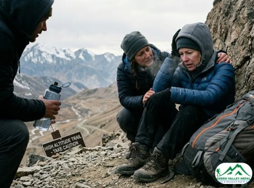
As you ascend into the rarefied air of the Himalayas, the captivating beauty of the Everest Gokyo Trek via Salleri is accompanied by an ever-present companion – altitude. With each step you take, the air grows thinner, the landscape transforms, and the challenges rise in tandem. Understanding the implications of altitude is not just essential; it's a crucial component of a safe and successful trek.
Imagine the air as a canvas painted with oxygen molecules. As you climb higher, this canvas becomes sparser, making every breath a bit more precious. Your body has to work harder to get the oxygen it needs at higher elevations because there is less oxygen available there. Breathlessness, exhaustion, and in extreme situations, altitude sickness, might result from this.
Altitude sickness is a threat when hiking at high altitudes. When your body struggles to adapt to the decreasing oxygen supply, this issue arises. From simple discomforts like headaches and nausea to more serious disorders like cerebral or pulmonary edema, symptoms can vary widely. It serves as a reminder that altitude affects your health and enjoyment of your journey and is more than just a chance amount.
The duality is that the Himalayas beckon, but they also demand respect. The key to conquering altitude lies in embracing gradual ascent. Imagine this journey not as a sprint but as a steady climb. Your body needs time to acclimatize, to adjust to the changing oxygen levels. Rushing through the altitudes can increase the risk of altitude sickness, potentially cutting short your adventure.
By allowing your body to adapt slowly, you're giving it the chance to thrive in challenging conditions. This means more than just stopping at designated acclimatization points; it's about listening to your body and heeding its cues. Rest when needed, hydrate continuously and move forward with caution.
Purpose of the Everest Gokyo Trek via Salleri Altitude Chart
The Everest Gokyo Trek via Salleri Altitude Chart is not merely a piece of paper; it's a potent tool that holds the key to unlocking a safe and enriching adventure. Designed with meticulous care, this chart serves as a compass that guides trekkers through the intricate dance of altitudes, enhancing the journey in ways both practical and profound.
Imagine the Altitude Chart as a visual symphony of elevation changes, mapping out the peaks and valleys of the trek ahead. It's a journey within a journey, allowing you to anticipate the rises and falls in altitude, just as you would anticipate the twists and turns of a thrilling story. This visual representation becomes your window into the challenges and triumphs that the Everest Gokyo Trek via Salleri promises.
But the Altitude Chart offers more than just an aesthetic revelation. It's a strategic asset that grants trekkers a multitude of advantages. It's like a strategic playbook that empowers you to make informed decisions about your trekking strategy. As you consult the chart, you're not just witnessing numbers; you're gaining insights into the altitude thresholds that demand special attention. This information allows you to plan your pace and acclimatization breaks, ensuring that your body adjusts optimally to the changing conditions.
As altitude isn't a monolith but a dynamic force, the Altitude Chart becomes your ally in acclimatization planning. It serves as a reminder that the trip is about accepting each stage with care and wisdom rather than merely focusing on getting to your final destination. Pacing oneself in accordance with the chart will give your body the time it needs to adjust, reduce your risk of experiencing altitude-related illnesses, and make your trip safer and more enjoyable.
Important Location on Everest Gokyo Trek via Salleri Trail
Phaplu (2,469m)
The moment you set foot in this quaint town, you are met with a calmness that sets the tone for the adventure that lies ahead. As a moderate introduction to the trekking experience, Phaplu's simplicity and tranquil ambiance let you take in the surroundings' beauty and the anticipation of what lies beyond.
Taksindo (2,930m)
Taksindo offers a glimpse into the local way of life and the authenticity of the Himalayan culture. As you interact with the warm-hearted locals and explore the traditional architecture, you'll sense the tranquil rhythm of mountain life that has endured for generations.
Kharikhola (2,040m)
Kharikhola welcomes you with its picturesque setting along the Dudh Koshi River. At an altitude of 2,040 meters, this charming village exudes a unique charm with its terraced fields, rustic houses, and prayer flags fluttering in the breeze. The soothing sound of the river accompanies your journey, providing a serene backdrop as you immerse yourself in the natural beauty and cultural richness of this Himalayan haven.
Paiya (2,730m)
Paiya emerges as a haven of hospitality nestled at an altitude of 2,730 meters. The village's hospitality matches the warmth of its landscape, and the local lodges offer you a cozy retreat after a day of trekking. The verdant surroundings, dotted with rhododendron blooms in season, create a refreshing ambiance that rejuvenates your spirit and invigorates your senses.
Phakding (2,610m)
Phakding, your gateway to the Everest region, unfolds as you cross the suspension bridges over the Dudh Koshi River. At an altitude of 2,610 meters, this welcoming village offers comfortable lodges and stunning river views. The sight of prayer flags fluttering in the wind and the sounds of flowing water accompany your arrival, marking the beginning of your deeper immersion into the heart of the Himalayas.
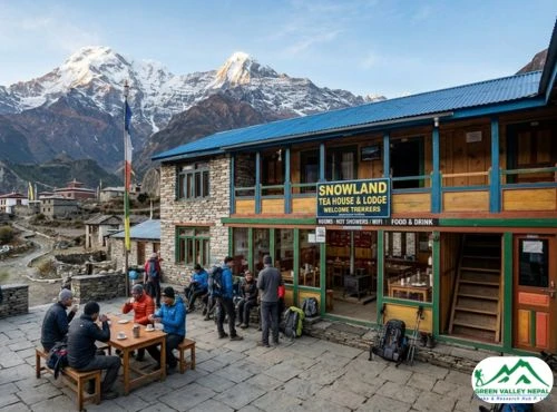
Namche Bazaar (3,440m)
Namche Bazaar stands as a vibrant Sherpa town that welcomes trekkers with its unique blend of culture and commerce. As you ascend to Namche, you'll witness the gradual transition from lush landscapes to more rugged terrain. This bustling hub serves as an acclimatization stop, where trekkers can indulge in luxurious accommodations, savor gourmet meals, and explore the local markets. The panoramic views of Everest and neighboring peaks provide a spectacular backdrop to your stay, making Namche Bazaar a memorable highlight on your journey.
Dhole (4,110m)
Dhole offers a serene escape amidst alpine landscapes. As you ascend to higher altitudes, the village's charm lies in its simplicity and tranquility. The crisp mountain air and stunning vistas create an ambiance of calmness that resonates with the rhythm of the Himalayas. Dhole provides a perfect pause along the trail, allowing you to acclimatize and absorb the breathtaking scenery that surrounds you.
Machhermo (4,470m)
Machhermo presents a serene sanctuary for trekkers amidst the high Himalayas. This picture-perfect location, which is encircled by high peaks, is proof of the area's unspoiled splendor. The breathtaking environment will make you feel in amazement and wonder as you rest in Machhermo, serving as a constant reminder of the remarkable nature of your adventure.
Gokyo (4,790m)
Gokyo reveals itself as a realm of turquoise lakes and breathtaking vistas. The series of stunning Gokyo Lakes, set against the backdrop of snow-clad peaks, create an ethereal scene that feels like something out of a dream. The serene ambiance and the reflection of the mountains on the tranquil waters make Gokyo a true gem of the Himalayas, inviting you to immerse yourself in its natural splendor.
Dragnag (4,750m)
Dragnag welcomes you at an altitude of 4,750 meters. The village's pristine landscapes and clear mountain air provide a unique sense of remoteness and tranquility. You'll be surrounded by unspoiled beauty at this place, which will let you feel connected to the mountains' unbridled force. Dragnag's appeal comes in its simplicity, providing a reprieve that enables you to consider the amazing scenery you have traveled through.
Dzongla (4,830m)
Nestled at an altitude of 4,830 meters, Dzongla presents a captivating panorama of the surrounding peaks. The village offers a moment of reflection and preparation as you traverse its rugged landscapes. Dzongla evokes a sense of grandeur that is both humbling and inspirational because of its mountainous backdrop. You'll find yourself surrounded by the grandeur of the Himalayas as you unwind in this high-altitude retreat.
Gorakshep (5,140m)
Gorakshep serves as your last stop before reaching the pinnacle of your journey. This remote outpost welcomes you with its unique charm amidst the high Himalayas. As you stand in the shadow of Everest's magnificence, you'll feel a sense of accomplishment that resonates through the thin mountain air. Gorakshep's location adds a touch of wonder to your experience, setting the stage for your final push toward Everest Base Camp.
Everest Base Camp (5,364m)
Everest Base Camp, the famous location where climbers start their ascent of the world's tallest peak, gives you a front-row view of Mount Everest's towering beauty. You'll sense a strong connection to the past and the spirit of discovery that characterizes this far-off and breathtaking location as you stand amidst the ice and rock.
Pheriche (4,240m)
Pheriche serves as a tranquil haven, offering a much-needed respite after the exhilaration of Everest Base Camp. The lush landscapes and comforting surroundings create a soothing ambiance, allowing you to reflect on the incredible journey you've undertaken and the memories you've collected along the way.
Kalapatthar (5,555m)
Climbing to a breathtaking altitude of 5,555 meters, Kalapatthar grants you a panoramic view that stretches from Everest to neighboring peaks. This vantage point rewards your efforts with a sweeping visual symphony of the world's highest mountains. As you stand on the summit of Kalapatthar, you'll feel a profound sense of accomplishment and awe, taking in a scene that remains etched in your memory forever.
Lukla (2,840m)
As your trek concludes, you return to Lukla at an altitude of 2,840 meters. This mountain town marks the end of your incredible journey, offering a mix of nostalgia and fulfillment. The familiar sights and sounds of Lukla, coupled with the memories of your trek, create a bittersweet moment as you bid farewell to the Himalayas and carry the spirit of your adventure with you.
Conclusion
The Everest Gokyo Trek via Salleri Route Map serves as the trekkers' guiding star, unveiling the intricate path that weaves through picturesque villages, rugged terrains, and awe-inspiring vistas. This comprehensive map offers not only direction but also a glimpse into the journey's essence, enhancing anticipation and navigation while ensuring a seamless exploration of the route's many wonders.
Crucial to this journey is the Everest Gokyo Trek via Salleri Altitude Chart, an unspoken companion that aids trekkers in conquering the challenges of elevation shifts. This chart meticulously outlines altitude gains, enabling trekkers to pace themselves, adjust their journey, and most importantly, acclimatize safely. It becomes a silent yet powerful mentor, fostering a harmonious alignment between trekkers and the high Himalayan altitudes.
At the heart of this remarkable experience lies a profound balance between preparation and surrender to the grandeur of nature. The Everest Gokyo Trek via Salleri Route Map and Altitude Chart encapsulates this balance, encapsulating the spirit of adventure and the wisdom of altitude management. As trekkers stand amidst the majestic landscapes, these tools stand as silent witnesses to triumph over challenges and an unwavering connection to the extraordinary landscapes of the Himalayas.

Arjun Pandey
Call us on WhatsApp+977 9841 392186OrChat with us