The Everest Base Camp Trek with Helicopter Return to Kathmandu is a thrilling and luxurious option for adventure seekers. Combining the classic trekking experience with a convenient helicopter ride, this journey offers a unique perspective of the majestic Himalayas. In this blog, we will explore the advantages of the helicopter return, explore the route through the Everest Base Camp Trek Helicopter Return Map, understand the significance of altitude through the Altitude Chart Map, and discover the important locations along this 10-day adventure.
Everest Base Camp Trek Helicopter Return Map

Advantages of Everest Trek with Helicopter Return
Trekkers looking for an amazing trip in the Himalayas have a unique and thrilling alternative with the Everest Base Camp Trek with Helicopter Return to Kathmandu. Opting for a helicopter return presents several advantages that make this journey truly exceptional.
- Time-saving: One of the most significant advantages of choosing a helicopter return is the time-saving aspect. The classic Everest Base Camp trek typically takes around 10 to 12 days to complete. However, with the helicopter return option, trekkers can significantly reduce their trekking duration and return to Kathmandu swiftly. This is particularly beneficial for those with limited time or who wish to maximize their experience in Nepal.
- Avoiding the Same Return Trail: The traditional Everest Base Camp trek follows the same trail for the return journey, retracing the steps taken during the initial ascent. While the trail offers different perspectives and experiences in each direction, some trekkers may prefer to explore new landscapes or simply avoid the physical strain of descending the same path. The helicopter return provides an alternative and exciting way to enjoy the Himalayan beauty from the air while bypassing the return trail.
- Aerial Views of Himalayan Landscapes: The helicopter ride from Gorak Shep, the last teahouse village before Everest Base Camp, offers breathtaking aerial views of the iconic Himalayan landscapes. Trekkers get an extraordinary opportunity to witness the towering peaks, dramatic glaciers, and pristine valleys from a bird's-eye perspective. This thrilling experience adds a touch of luxury and uniqueness to the adventure.
- Comfort and Convenience: The helicopter return allows trekkers to enjoy the comfort and convenience of flying back to Kathmandu. After days of trekking and exploring the rugged terrains of the Everest region, the helicopter provides a smooth and effortless way to conclude the journey. Trekkers can relish the adventure they have just completed while flying high above the majestic Himalayas.
- A Grand Finale: The helicopter return serves as a grand finale to an already extraordinary trekking experience. Trekkers feel a feeling of success as they enjoy a comfortable helicopter ride while taking in the majestic Himalayas. The aerial perspective offers a unique opportunity to appreciate the vastness and magnificence of the Everest region, leaving trekkers with lasting memories to cherish.
Everest Base Camp Trek Helicopter Return Route Map
When embarking on the adventurous journey of the Everest Base Camp Trek with Helicopter Return to Kathmandu, a comprehensive route map serves as an invaluable tool. This map not only offers essential information about the trekking trail but also provides trekkers with insights into distances, key landmarks, and the entire itinerary. Let's explore how the Everest Base Camp Trek Helicopter Return to Kathmandu Route Map emphasizes the significance of a map in navigating this extraordinary expedition.
- Guiding the Way: The Everest Base Camp Trek Helicopter Return Route Map acts as a guiding compass, ensuring that trekkers stay on the designated path from the beginning in Lukla to the ultimate destination of Everest Base Camp and back to Kathmandu via helicopter. By following the trail indicated on the map, trekkers can confidently navigate the trek and avoid getting lost amidst the vast Himalayan landscapes.
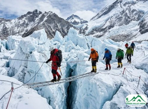
- Essential Route Information: The route map provides trekkers with essential route information, detailing the key locations along the journey. Starting from Lukla, trekkers traverse through the vibrant Sherpa town of Namche Bazaar, the iconic Tengboche Monastery, and the picturesque village of Dingboche. The map also marks the challenging terrains of Lobuche and Gorak Shep, leading trekkers to the ultimate destination of Everest Base Camp.
- Estimating Distances: A crucial aspect of the Everest Base Camp Trek Helicopter Return to Kathmandu is the ability to estimate distances between each location. The route map provides valuable insights into the length of each day's hike, allowing trekkers to plan their itineraries and manage their time effectively. This knowledge ensures that trekkers can allocate sufficient time for rest, acclimatization, and exploration of the magnificent surroundings.
- Marking Landmarks and Highlights: The route map highlights significant landmarks and highlights along the way. Trekkers can easily identify cultural gems like Tengboche Monastery, natural wonders like the Khumbu Glacier, and panoramic viewpoints like Kala Patthar. Trekkers can fully immerse themselves in the Everest region's rich cultural and environmental treasures thanks to this graphic portrayal, which gives the trekking experience more depth and perspective.
- Enabling Informed Decision Making: By referring to the Everest Base Camp Trek Helicopter Return Route Map, trekkers can make informed decisions about their journey. They can plan their rest days, choose the best acclimatization stops, and select alternative routes if desired. This empowerment ensures a well-prepared and enjoyable trekking experience.
Everest Base Camp Trek Helicopter Return to Kathmandu Altitude Map

Understanding Altitude and Acclimatization
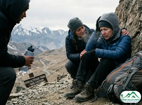
Understanding altitude is of paramount importance in the Everest Base Camp Trek with Helicopter Return to Kathmandu. The altitude progressively rises as hikers ascend through the difficult terrain of the Himalayas, bringing both difficulties and awe-inspiring experiences. Let's dig into the significance of altitude in this journey and the essential aspects of acclimatization, emphasizing the importance of gradual ascent, particularly during the helicopter ride.
- Significance of Altitude: Altitude plays a critical role in the Everest Base Camp Trek with Helicopter Return to Kathmandu. As trekkers venture into higher elevations, the air becomes thinner, and oxygen levels decrease. Due to decreased oxygen levels in the air at high altitudes, Altitude-related ailments can appear such as:
- Acute Mountain Sickness (AMS)
- High-Altitude Pulmonary Edema (HAPE)
- High-Altitude Cerebral Edema (HACE)
Understanding the effects of altitude and preparing for its challenges are essential for a safe and successful trekking experience.
- Challenges of Acclimatization: The process of acclimatization enables the body to adjust to shifting altitudes and perform at its best in surroundings with low oxygen levels. The Everest Base Camp Trek with Helicopter Return to Kathmandu involves ascending to high altitudes relatively quickly, increasing the risk of altitude sickness. Trekkers must take necessary precautions when they sense the signs and symptoms of AMS like:
- Headache
- Nausea
- Dizziness
- Fatigue
- Importance of Gradual Ascent: A key strategy to mitigate altitude-related risks is to adopt a gradual ascent approach. The Everest Base Camp Trek Helicopter Return to Kathmandu Altitude Map highlights the key acclimatization stops along the trek, such as Namche Bazaar, Dingboche, and Lobuche. Trekkers are encouraged to spend extra time at these locations to allow their bodies to adjust to the increasing altitude. By following a well-designed itinerary that incorporates rest days and acclimatization stops, trekkers significantly reduce the chances of developing altitude sickness.
- Acclimatization during Helicopter Ride: Even during the helicopter ride back to Kathmandu, acclimatization remains a crucial consideration. The helicopter ascends rapidly to higher elevations, which can pose challenges to trekkers' bodies. Keep yourself hydrated, take deep breaths, and monitor yourself for any signs of altitude sickness while climbing. The pilot's experience and expertise in high-altitude flying also contribute to a smooth and safe journey.
- Trekker's Responsibility: As trekkers embark on the Everest Base Camp Trek with Helicopter Return to Kathmandu, it is their responsibility to prioritize their well-being. Being attentive to their body's signals, adhering to the advice of experienced guides, and maintaining a positive attitude contribute to a successful and fulfilling trekking experience.
Everest Base Camp Trek Helicopter Return Altitude Chart Map
The Everest Base Camp Trek Helicopter Return Altitude Chart Map is an invaluable tool that offers trekkers a visual representation of the altitude gained throughout the entire expedition. This comprehensive chart serves multiple purposes and provides numerous benefits, enhancing the trekking experience and ensuring a safe and enjoyable journey. Let's explore the purpose and advantages of the Altitude Chart Map, which vividly illustrates the elevation changes during both the trek and the helicopter journey.
- Purpose of the Altitude Chart Map: The primary purpose of the Altitude Chart Map is to provide trekkers with a clear understanding of the elevation changes they will encounter during the Everest Base Camp Trek with Helicopter Return to Kathmandu. This visual representation allows trekkers to anticipate the varying altitudes and prepare accordingly for the challenges that come with high-altitude trekking. The Altitude Chart Map also aids in planning the itinerary, making informed decisions about rest days, and ensuring proper acclimatization.
- Visualizing Altitude Gain: The Altitude Chart Map visually displays the gradual ascent from the starting point in Lukla to the ultimate destination of Everest Base Camp, and the subsequent descent via helicopter back to Kathmandu. Trekkers can easily track their progress and celebrate their achievements as they gain altitude, reaching significant milestones along the trek. Witnessing the altitude gain through this chart adds excitement and motivation to the journey.
- Acclimatization Planning: One of the critical aspects of high-altitude trekking is acclimatization. The Altitude Chart Map highlights the key acclimatization stops along the trek, such as Namche Bazaar, Dingboche, and Lobuche. Trekkers can strategically plan their acclimatization days, allowing their bodies to adapt gradually to the increasing elevation. This proactive approach significantly reduces the risk of altitude-related illnesses and ensures a safer and more enjoyable trek.
- Identifying Challenging Sections: The Altitude Chart Map helps trekkers identify the sections of the trek with significant altitude gains, such as ascending to Everest Base Camp and crossing high passes like Cho La Pass. Being aware of these challenging segments allows trekkers to mentally prepare and allocate sufficient time for rest and acclimatization, making these parts of the journey more manageable.
- Helicopter Journey Elevation: In addition to the trekking trail, the Altitude Chart Map includes the elevation gain during the helicopter ride back to Kathmandu. Trekkers can observe the rapid ascent and descent during the flight, further enhancing their understanding of the journey's elevation changes. This awareness contributes to a smoother and more enjoyable helicopter experience.
Important Locations of the 10-Day Everest Trek Helicopter Return to Kathmandu
Embark on an extraordinary adventure through the heart of the Himalayas with the 10-Day Everest Base Camp Trek with Helicopter Return to Kathmandu. You will enjoy a once-in-a-lifetime adventure on a fantastic journey through various landscapes, bustling Sherpa towns, and famous sites. Let's explore the significant locations along this trek, each contributing to the magic of this remarkable expedition.
- Lukla (2,860m): The Gateway to Adventure
Lukla serves as the starting point of the Everest Base Camp Trek with Helicopter Return to Kathmandu. This mountainous airstrip is renowned for its thrilling and challenging runway, nestled amidst the towering peaks. As you set foot in Lukla, you'll be greeted by the stunning Himalayan landscapes, marking the beginning of your extraordinary adventure.
- Namche Bazaar (3,440m): The Vibrant Sherpa Town
Namche Bazaar, a vibrant Sherpa town, awaits trekkers with its lively market, warm hospitality, and breathtaking vistas. Situated in a natural amphitheater, Namche serves as a vital acclimatization stop. You will enjoy a once-in-a-lifetime adventure on a fantastic journey through various landscapes, bustling Sherpa towns, and famous sites.
- Tengboche (3,860m): Cultural Haven and Panoramic Views
Tengboche is home to the iconic Tengboche Monastery, a spiritual and cultural center in the Khumbu region. The monastery's rich history and intricate architecture create a serene ambiance. Surrounding Tengboche are panoramic views of Everest, Ama Dablam, and other majestic peaks, making this location a photographer's paradise.
- Dingboche (4,410m): Scenic Beauty and Acclimatization
Dingboche, nestled amidst stunning landscapes, offers trekkers breathtaking views of the surrounding peaks. As an acclimatization stop, trekkers spend time here to allow their bodies to adjust to the increasing altitude. The terraced fields and stone-walled houses add to the picturesque charm of this scenic village.
- Lobuche (4,940m): Challenges and Proximity to Everest
Lobuche marks a significant stage in the journey, with trekkers experiencing more challenging terrain and thinner air. Despite the difficulties, the proximity to Everest Base Camp adds excitement and motivation. Prepare for the final ascent to the ultimate destination as you soak in the beauty of the high Himalayas.
- Gorak Shep (5,164m): Amidst the High Himalayas
Gorak Shep is the last resting point before the helicopter ride back to Kathmandu. This remote location offers trekkers a unique experience amid the high Himalayas. The tranquil ambiance and majestic views create an ideal setting for reflection and celebration of your trekking achievements.
- Everest Base Camp (5,364m): A Glimpse of Triumph
The ultimate destination of the trek, Everest Base Camp, is a place of triumph and awe. Trekkers take in the splendor of the Khumbu Glacier and the neighboring peaks while positioned at the base of the highest mountain in the world. Capture this unforgettable moment and cherish the memories of this remarkable achievement.
- Kala Patthar (5,545m): The Ultimate Vantage Point
Kala Patthar is the ultimate vantage point for breathtaking views of Mount Everest and nearby peaks. Witness the dawn above Everest, which will forever imprint the magnificence of the Himalayas on your spirit.
- Kathmandu (1,400m): The Return Journey
As the trek concludes, the helicopter ride back to Kathmandu offers an exclusive aerial view of the majestic Himalayan landscapes. Reflect on the journey's triumphs, the encounters with Sherpa culture, and the bond forged with fellow trekkers.
Conclusion
With its unique combination of traditional trekking and the ease and excitement of a helicopter flight, the Everest Base Camp Trek with Helicopter Return to Kathmandu promises to be an unforgettable journey. With a clear understanding of the route through the Everest Base Camp Trek Helicopter Return to Kathmandu Map and the significance of altitude via the Altitude Chart Map, trekkers can embark on this unforgettable journey with confidence. Explore the vibrant Sherpa culture, immerse in the breathtaking landscapes, and create lasting memories of the Everest region in this luxurious and exclusive trekking experience.