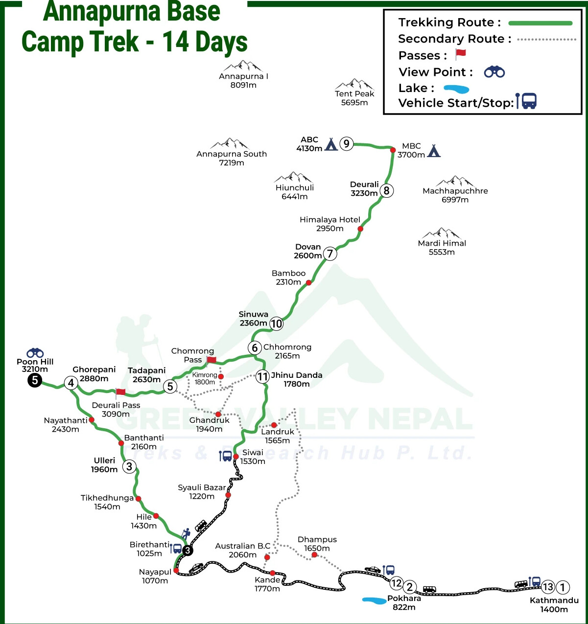
Annapurna Base Camp Trek Map: Route Explanation
The Annapurna Base Camp Trek trail map depicts the entire journey along the route leading out of Kathmandu via Pokhara to enter into the very core of the Annapurna region, highlighting the major destinations along the way, including Ulleri, Ghorepani and Poon Hill, Chomrong, Dovan, Deurali, and Machhapuchhre Base Camp lead up to the Annapurna Base Camp.
It graphically symbolizes the trekking route using beautiful forests, terraced fields, and mountainous sceneries, and thus, the trekkers can get a better idea of the day-to-day advancement and major milestones as they move along.
The map shows the regular route as well as the key landmarks during the adventure, like Poon Hill (3,210m), the primary acclimatization and viewing point, and Machhapuchhre Base Camp (3,700m), the primary viewing point on the reverse.
The route map is also useful in navigation and route planning as it presents a clear view of what is ahead on the trail with points of ascent and returning route clear from each other, making the trekkers well prepared for the venture ahead.
Annapurna Base Camp Trek Distance & Walking Hours
The Annapurna Base Camp Trek covers approximately 110 kilometers (68 miles) of total trekking distance from the starting point at Birethanti to the final destination at Annapurna Base Camp and back to Siwai. This comprehensive journey takes you through diverse terrains, ranging from subtropical valleys at 1,263 meters to the high-altitude amphitheater of ABC at 4,130 meters.
Day-by-Day Distance Breakdown
Day | Route | Distance (km/miles) | Walking Hours | Max Altitude Gain / Loss |
1 | Birethanti to Ulleri | 8.8 km / 5.4 miles | 5–6 hours | +697 m (1,263 m → 1,960 m) |
2 | Ulleri to Ghorepani | 10.3 km / 6.4 miles | 4–5 hours | +920 m (1,960 m → 2,880 m) |
3 | Ghorepani to Poon Hill to Tadapani | 11 km / 6.8 miles | 5–6 hours | +330 m (2,880 m → 3,210 m at Poon Hill) |
4 | Tadapani to Chomrong | 10 km / 6 miles | 4–5 hours | −465 m descent (2,630 m → 2,165 m) |
5 | Chomrong to Dovan | 8.6 km / 5 miles | 5–6 hours | +435 m (2,165 m → 2,600 m) |
6 | Dovan to Deurali | 7.7 km / 4.7 miles | 4–5 hours | +630 m (2,600 m → 3,230 m) |
7 | Deurali to Annapurna Base Camp (via MBC) | 9.2 km / 5.7 miles | 4–5 hours | +900 m (3,230 m → 4,130 m) |
8 | Annapurna Base Camp to Sinuwa | 19 km / 11.8 miles | 7–8 hours | −1,770 m descent (4,130 m → 2,360 m) |
9 | Sinuwa to Jhinu Danda | 10 km / 6 miles | 4–5 hours | −580 m descent (2,360 m → 1,780 m) |
10 | Jhinu Danda to Siwai | 4.3 km / 2.6 miles | 3–4 hours | −250 m descent (1,780 m → 1,530 m) |
Estimated Walking Hours Per Day
The daily walking hours on the Annapurna Base Camp trek vary based on terrain difficulty, elevation gain, and individual fitness levels. When following your ABC trek map, these time estimates help you plan rest stops and photography opportunities:
Key Points about Walking Hours:
- Average Daily Trekking: 4-6 hours of walking
- Longest Day: Day 8 (ABC to Sinuwa) at 7-8 hours
- Shortest Day: Day 10 (Jhinu Danda to Siwai) at 3-4 hours
- Steepest Ascent Days: Days 1, 2, 6, and 7 require more stamina due to significant altitude gain
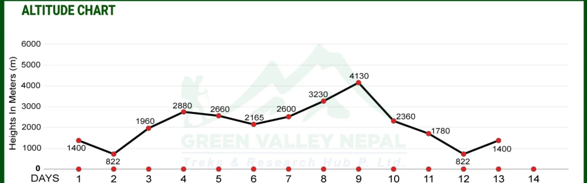
Annapurna Base Camp Trek Altitude Chart
The altitude profile of Annapurna Base Camp Trek is depicted in the chart below consisting of the location hierarchy the Kathmandu at (1,400m) then Pokhara at (822m), Ulleri at (1,960m), Ghorepani at (2,880m), Poon Hill at (3,210m), Machhapuchhre Base Camp at (3,700m) as the highest point and Annapurna Base Camp at (4,130m).
Then it shows the descent path via the Sinuwa (2,360m) and Jhinu Danda (1,780m) on the way back to Pokara. Using this chart, trekkers can keep account of elevation gained and lost day by day, learn the demands of acclimatization, and do physical training to negotiate ascents and descents in the Himalayan setting.
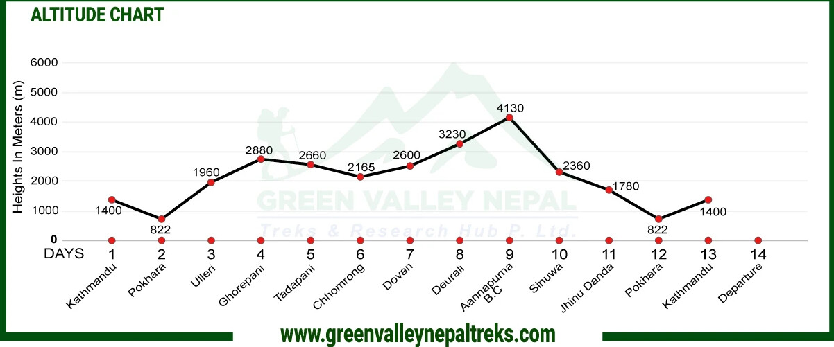
As it demonstrates the gradual rise to Annapurna Base Camp (4,130m) and subsequent descent in detail, the chart allows trekkers to expect difficult stages, adjust the speed of trekking, and reduce the probability of altitude sickness.
It also gives a clear description of how elevation affects the amount of walking hours each day, energy, and rest days, and thus, the trekkers are much more physically and mentally prepared. Finally, an altitude chart helps in safe planning, efficient acclimatization, and easier trekking.
Route Variations Shown on Annapurna Base Camp Trek Map
Annapurna Base Camp Trek Map via Poon Hill
The classic Annapurna Base Camp trek via Poon Hill is the most popular and rewarding route variation, combining cultural immersion with breathtaking panoramic mountain views. This route is ideal for trekkers seeking the complete Annapurna experience.
Day | Route Segment | Distance (km/miles) | Altitude Range | Duration |
1 | Birethanti → Ulleri | 8.8 km / 5.4 miles | 1,263 m → 1,960 m | 5–6 hours |
2 | Ulleri → Ghorepani | 10.3 km / 6.4 miles | 1,960 m → 2,880 m | 4–5 hours |
3 | Ghorepani → Poon Hill → Tadapani | 11 km / 6.8 miles | Up to 3,210 m (Poon Hill) | 5–6 hours |
4 | Tadapani → Chomrong | 10 km / 6 miles | 2,630 m → 2,165 m | 4–5 hours |
5–7 | Chomrong → Dovan → Deurali → Annapurna Base Camp | 25.5 km / 15.8 miles | 2,165 m → 4,130 m | 4–6 hours per day |
Direct Annapurna Base Camp Trek Route Map
The direct route to Annapurna Base Camp bypasses Poon Hill and Ghorepani, offering a faster, more focused approach to the sanctuary. This variation appeals to trekkers with limited time or those who have already experienced Poon Hill on previous treks.
Day | Route Segment | Distance (km/miles) | Altitude Range | Walking Hours |
1 | Birethanti → Jhinu Danda | 12 km / 7.4 miles | 1,263 m → 1,780 m | 5–6 hours |
2 | Jhinu Danda → Chomrong | 10 km / 6 miles | 1,780 m → 2,165 m | 4–5 hours |
3 | Chomrong → Bamboo | 9 km / 5.5 miles | 2,165 m → 2,310 m | 5–6 hours |
4 | Bamboo → Deurali | 7.3 km / 4.5 miles | 2,310 m → 3,230 m | 4–5 hours |
5 | Deurali → Annapurna Base Camp (via MBC) | 9.2 km / 5.7 miles | 3,230 m → 4,130 m | 4–5 hours |
Short Annapurna Base Camp Trek Route Map
The short ABC trek is designed for time-constrained trekkers who want to experience the Annapurna Sanctuary without spending two weeks on the trail. This condensed itinerary requires good fitness levels and rapid acclimatization.
Day | Route Segment | Distance | Altitude Range | Duration |
1 | Pokhara → Siwai (drive) → Chomrong | 15 km trek | 1,530 m → 2,165 m | 6–7 hours |
2 | Chomrong → Bamboo | 9 km / 5.5 miles | 2,165 m → 2,310 m | 5–6 hours |
3 | Bamboo → Deurali | 7.3 km / 4.5 miles | 2,310 m → 3,230 m | 4–5 hours |
4 | Deurali → Annapurna Base Camp → Machhapuchhre Base Camp | 9.2 km / 5.7 miles | 3,230 m → 4,130 m | 5–6 hours |
5 | Machhapuchhre Base Camp → Bamboo | 16.5 km / 10.2 miles | 3,700 m → 2,310 m | 6–7 hours |
6 | Bamboo → Jhinu Danda → Siwai (drive to Pokhara) | 13 km trek | 2,310 m → 1,530 m | 5–6 hours |
Return Route Options from Annapurna Base Camp
Once you've achieved your goal of reaching Annapurna Base Camp, your trek map shows several return options, each offering different experiences and time frames.
Option 1: Retrace the Original Route (Most Common)
Route | Distance | Duration | Advantages |
ABC → Bamboo | 16.5 km | 1 day | Familiar trail, downhill ease |
Bamboo → Jhinu Danda | 11 km | 1 day | Hot springs relaxation |
Jhinu Danda → Siwai → Pokhara | 4 km + drive | Half day | Quick return to Pokhara |
Option 2: Alternative Descent via Landruk-Dhampus
Route | Distance | Duration | Highlights |
ABC → Chomrong | 22 km | 1 day | Long descent day |
Chomrong → Landruk | 8 km | 4 hours | Traditional Gurung village |
Landruk → Dhampus | 10 km | 5 hours | Ridge walking, mountain views |
Dhampus → Pokhara | 6 km + drive | 3 hours | Australian Camp viewpoint |
Option 3: Express Helicopter Return
Departure Point | Flight Time | Cost Range | Experience |
ABC to Pokhara | 25-30 minutes | $400-600 per person | Ultimate aerial views |
MBC to Pokhara | 20-25 minutes | $350-500 per person | Slightly lower cost |
Option 4: Extended Loop via Ghandruk
Route Segment | Distance | Duration | Cultural Value |
ABC → Chomrong → Ghandruk | 25 km | 2 days | Largest Gurung village |
Ghandruk → Nayapul → Pokhara | 15 km + drive | 1 day | Museum, traditional architecture |
Major Locations on Annapurna Base Camp Trek
- Kathmandu (1,400m): Capital city of Nepal, and the hub upon the trek begins, providing numerous opportunities to experience cultural heritage sites and have a pre-trip briefing prior to heading into the mountains.
- Pokhara (822m): Beautiful lakeside city with Phewa Lake and a showcase of the Annapurna and Machhapuchhre ranges, with entrance to the trek.
- Ulleri (1,960m): A traditional Gurung and Magar village at the end of a steep uphill climb, with terraced fields in view and the first view of high Himalaya scenery.
- Ghorepani (2,880m): A very common stop during the trek, in a forest of rhododendrons and a starting point of a brief walk to the popular, scenic Poon Hill.
- Poon Hill (3,210m): This looks out to the Annapurna and Dhaulagiri, both to experience sunrise, which is one of the major highlights of the trek.
- Tadapani (2,630m): It is a resting place type of village amidst forests, but you get relatively up-close glimpses of Annapurna South, Machhapuchhre, and Hiunchuli.
- Chomrong (2,165m): A Gurung settlement that is the largest in the area and a gateway to Annapurna Sanctuary with breathtaking scenery of Machhapuchhre.
- Dovan (2,600m): A calm resting place amidst the green pine valley, and it gives some sense of isolation with a calming roar of the Modi Khola River.
- Deurali (3,230m): A mountainous halt and the last high stop before the base camps, surrounded by cliffs and giving a view of the alpine landscape.
- Machhapuchhre Base Camp (3,700m): A stunning campsite with one of the best possible views in the world; the Machhapuchhre (Fishtail Mountain) looms just above at close quarters.
- Annapurna Base Camp (4,130m): The final destination of the trek, deep into the Annapurna Sanctuary with several of the highest mountains in the world, including Annapurna I, Hiunchuli, Machhapuchhre, and many more, presents indeed the unique Himalayan spectacular view.
- Sinuwa (2,360m): A small village on the way back (also a good camping site) found on a ridge with wonderful scenery over the valley and other mountains.
- Jhinu Danda (1,780m): This village is well known due to its natural hot springs located near the Modi Khola River, where trekkers get a chance to relax and cure their tired muscles after spending days of trekking.
Conclusion
The Annapurna Base Camp Trek is one of the trekking adventures in Nepal that offers all the landscapes, villages, and scenic views of mountains in the country.
The route map and altitude chart also assist the trekkers to have a visual perception of the path, where they may expect elevation changes, and prepare to acclimatize safely without expecting any complications.
The cultural beauty of Kathmandu, Pokhara, the view of the sunrise at Poon hill and the breathtaking panorama at Annapurna Base Camp (4130m) are just some of the highlights that make the adventure beautiful and colorful.
The trek is a complete combination of natural attractions, cultural experience and trekking challenges at high altitude, which provides the trekkers with an unforgettable memory of the Himalayas.
Frequently Asked Questions (FAQs)
- Is the Annapurna Base Camp Trek Map Enough for Beginners?
Yes, a quality Annapurna Base Camp trek map is sufficient for beginners during peak season (October-November, March-April), especially when combined with a GPS app like Maps.me. The ABC trail is well-marked with ACAP signboards, frequent teahouses, and high trekker traffic, making navigation straightforward.
- Can I Trek Annapurna Base Camp Without a Guide Using the Map?
Yes, you can absolutely trek to Annapurna Base Camp without a guide using just a map and a GPS app. Nepal does not require guides for the ABC trek; you only need an ACAP permit (NPR 3,000) and a TIMS card (NPR 2,000).
- Is the Annapurna Base Camp Trail Well Marked?
Yes, the Annapurna Base Camp trail is very well marked throughout the entire route. ACAP (Annapurna Conservation Area Project) maintains official blue and white signboards at all major trail junctions.
- Which Route Is Best on the Annapurna Base Camp Trek Map?
The classic route via Ghorepani-Poon Hill is best for most trekkers. Route: Birethanti → Tikhedhunga → Ulleri → Ghorepani → Poon Hill → Tadapani → Chomrong → Sinuwa → Bamboo → Deurali → MBC → ABC
- Is the Annapurna Base Camp Trek Map Different from the Annapurna Circuit Map?
Yes, the Annapurna Base Camp (ABC) trek map and Annapurna Circuit trek map are completely different, as they cover distinct routes with different starting points, destinations, and terrain.