Annapurna Circuit Trek Map: Route Explanation
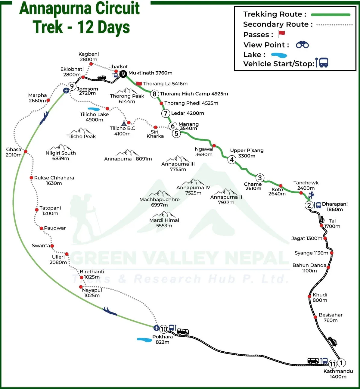
Besisahar to Dharapani (Lower Annapurna Section)
This section marks the beginning of the Annapurna Circuit for most trekkers. On the map, the trail starts from Besisahar and gradually follows the Marsyangdi River valley up to Dharapani.
- Distance: Approximately 30–35 km (varies based on trial choices)
- Walking hours: 3–6 hours per day over 2–3 days
- Road vs trail clarity: The map clearly shows sections where jeep roads overlap with trekking trails. Many trekkers use side trails to avoid the road, and a good map helps you choose quieter, more scenic paths.
- Map reference: Look for villages such as Bhulbhule, Jagat, and Tal, which are clearly marked and help confirm you are on the correct trail.
This lower section stays below 2,000 meters, making it ideal for warming up before higher altitude trekking.
Dharapani to Manang (Mid-Altitude Zone)
From Dharapani, the map shows the route entering the restricted Annapurna Conservation Area, where the scenery and altitude begin to change noticeably.
- Gradual altitude gain: The altitude chart shows a steady rise rather than a sharp climb, which helps the body adapt naturally.
- Key villages: Important stops marked on the map include Chame, Pisang (Upper and Lower), and Manang. These villages are essential reference points for distance and elevation tracking.
- Acclimatization preparation: The map and altitude chart together highlight Manang (around 3,540m) as the main acclimatization hub. Side hikes such as Gangapurna Lake or Ice Lake are often indicated on detailed maps, helping trekkers plan proper rest days.
This zone is crucial for preparing your body for the high pass ahead.
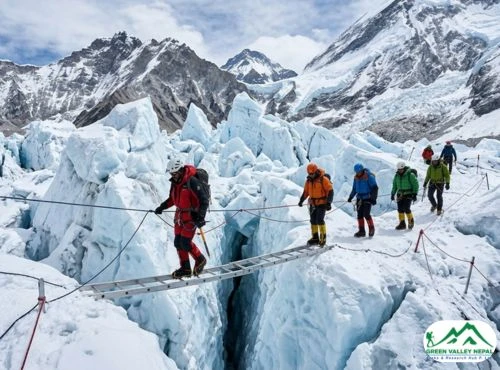
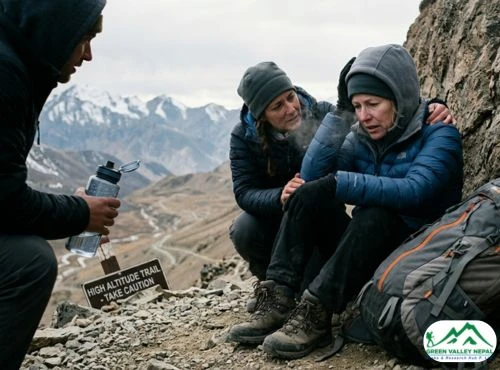
Manang to Thorong La Pass (High-Risk Zone)
This is the most sensitive and demanding part of the Annapurna Circuit, clearly emphasized on the trek map and altitude chart.
- Altitude danger section: The altitude chart shows a sharp rise from Manang to Thorong La Pass (5,416m), signaling a higher risk of altitude sickness.
- Early crossing route on the map: The map highlights the route from Thorong Phedi or High Camp to the pass, showing why trekkers must start early in the morning to avoid strong winds and snow.
- Weather-sensitive points: Exposed sections near the pass are usually marked, helping trekkers understand where weather changes can directly impact safety.
Careful map reading in this section is essential for timing, acclimatization, and overall safety.
Thorong La to Jomsom (Descent Routes)
After crossing Thorong La, the trek enters the Mustang region, and the map becomes especially useful due to multiple route options.
- Multiple exit options shown on the map: From Muktinath, the map displays routes leading to Jomsom, Tatopani, or further down to Nayapul, allowing trekkers to customize their exit.
- Road impact explanation: The map clearly shows where roads run parallel to the trail, especially between Muktinath and Jomsom. Trekkers can decide whether to walk the road, take side trails, or use local transport.
This descent section is physically easier but still requires good navigation to choose the best trekking experience.
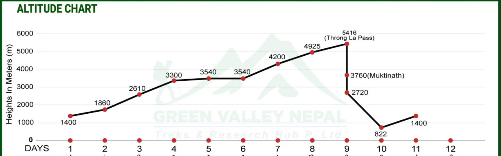
Annapurna Circuit Trek Altitude Map & Elevation Profile
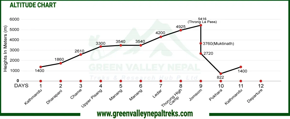
Visual Altitude Chart
A visual altitude chart shows the rise and fall of elevation from the starting point to the end of the trek. On the Annapurna Circuit, this chart clearly highlights:
- A gradual climb from the low valleys to mid-altitude villages
- A steep elevation gain after Manang
- The highest point at Thorong La Pass (5,416m)
- A rapid descent toward Muktinath and Jomsom
When you look at the altitude chart, the sharp upward slope before Thorong La immediately signals a high-risk zone, helping trekkers prepare mentally and physically.
Daily Sleeping Altitude
One of the most useful features of an altitude map is that it shows daily sleeping altitudes, not just the highest walking point of the day. This is important because altitude sickness is strongly linked to how high you sleep.
Typical sleeping altitude progression shown on the map includes:
- Lower villages below 2,000m in the early days
- Mid-altitude stops like Chame and Pisang
- Manang (around 3,540m) is a key rest point
- Higher overnight stays at Yak Kharka and Thorong Phedi / High Camp
A well-designed map helps trekkers avoid the mistake of ascending too quickly.
AMS Risk Zones
The altitude map also highlights AMS (Acute Mountain Sickness) risk zones, usually starting above 2,500m and increasing significantly beyond 3,500m.
Key AMS risk areas marked on the map include:
- The trail between Chame and Manang, where the altitude gain becomes noticeable
- The section from Manang to Thorong Phedi, where symptoms often begin if acclimatization is skipped
- Thorong La Pass, which is the highest and most demanding point of the trek
Seeing these zones visually helps trekkers take early precautions.
Annapurna Circuit Trek Map Variations
Annapurna Circuit Trek Map via Tilicho Lake
| Route | Distance (km/miles) | Trekking Hours | Altitude (m / ft) | Altitude Gain / Loss |
|---|
| Drive from Kathmandu to Dharapani | 234 km / 145 miles | 8–9 hrs | 1,860 m / 6,102 ft | +460 m |
| Trek from Dharapani to Chame | 15.5 km / 9.6 miles | 5–6 hrs | 2,610 m / 8,562 ft | +750 m |
| Trek from Chame to Upper Pisang | 13.5 km / 8 miles | 5–6 hrs | 3,300 m / 10,826 ft | +690 m |
| Trek from Upper Pisang to Manang | 17.2 km / 10.6 miles | 7–8 hrs | 3,540 m / 11,614 ft | +240 m |
| Trek from Manang to Siri Kharka | 12 km / 7.4 miles | 4–5 hrs | 4,060 m / 13,320 ft | +520 m |
| Trek from Siri Kharka to Tilicho Base Camp | 8 km / 4.9 miles | 4–5 hrs | 4,150 m / 13,615 ft | +90 m |
| Trek from Tilicho Lake to Siri Kharka | 11 km / 6.8 miles | 5–6 hrs | 4,060 m / 13,320 ft | −90 m |
| Trek from Siri Kharka to Yak Kharka | 8.4 km / 5 miles | 4–5 hrs | 4,018 m / 13,182 ft | −42 m |
| Trek from Yak Kharka to Thorong Phedi | 8.5 km / 5 miles | 4–5 hrs | 4,550 m / 14,927 ft | +532 m |
| Trek from Thorong Phedi to Muktinath (via Thorong La Pass) | 15.6 km / 9.6 miles | 8–9 hrs | 3,760 m / 12,335 ft | +866 m / −1,656 m |
| Trek from Muktinath to Jomsom | 16.4 km / 10 miles | 8–9 hrs | 2,720 m / 8,923 ft | −1,040 m |
| Flight from Jomsom to Pokhara | 160 km / 99.4 miles | 1 hr | 822 m / 2,696 ft | −1,898 m |
| Drive from Pokhara to Kathmandu | 205 km / 127 miles | 7–8 hrs | 1,400 m / 4,593 ft | +578 m |
The Tilicho Lake route is one of the most scenic side trips shown on the Annapurna Circuit map and is often chosen by trekkers looking for a more adventurous experience.
- Where the route splits: The map shows the main trail splitting near Manang / Khangsar, where the route diverts west toward Tilicho Base Camp before rejoining the main circuit near Yak Kharka.
- Extra days required: This variation typically adds 2 to 4 extra days, depending on acclimatization and weather conditions.
- Difficulty level: The altitude map highlights higher exposure and steeper sections, making this route moderate to challenging. Landslide-prone areas are often marked, emphasizing the need for good weather and careful planning.
This option is ideal for trekkers who want to see one of the world’s highest lakes at 4,919m.
Annapurna Circuit Trek Map with Nar Phu Valley
| Route | Distance (km/miles) | Trekking Hours | Altitude (m / ft) | Altitude Gain / Loss |
|---|
| Drive Besishahar to Dharapani | 221 km / 137 miles | 8–9 hrs | 1,860 m / 6,102 ft | +460 m |
| Trek from Dharapani to Koto | 14 km / 8.6 miles | 5–6 hrs | 2,600 m / 8,530 ft | +740 m |
| Trek from Koto to Meta | 20 km / 12.4 miles | 8–9 hrs | 3,560 m / 11,679 ft | +960 m |
| Trek from Meta to Phu Village | 19 km / 11.8 miles | 7–8 hrs | 4,080 m / 13,385 ft | +520 m |
| Trek from Phu Village to Nar Phedi | 18.5 km / 11.4 miles | 7 hrs | 3,490 m / 11,450 ft | −590 m |
| Trek from Nar Phedi to Nar Village | 7 km / 4 miles | 3 hrs | 4,150 m / 13,615 ft | +660 m |
| Trek from Nar Village to Ngawal via Kang La Pass | 18 km / 11 miles | 9–10 hrs | 3,660 m / 12,007 ft | +1,155 m / −1,645 m |
| Trek from Ngawal to Manang | 8 km / 4.9 miles | 4–5 hrs | 3,540 m / 11,614 ft | −120 m |
| Trek from Manang to Yak Kharka | 10 km / 6 miles | 4–5 hrs | 4,050 m / 13,287 ft | +510 m |
| Trek from Yak Kharka to Thorong High Camp | 8 km / 4.9 miles | 3–4 hrs | 4,925 m / 16,158 ft | +875 m |
| Trek from Thorong High Camp to Muktinath via Thorong La Pass, then Jomsom | 16.4 km / 10 miles | 8–9 hrs | 2,720 m / 8,923 ft | +491 m / −2,696 m |
| Flight from Jomsom to Pokhara | 160 km / 99.4 miles | 1 hr | 822 m / 2,696 ft | −1,898 m |
| Drive from Pokhara to Kathmandu | 205 km / 127 miles | 7–8 hrs | 1,400 m / 4,593 ft | +578 m |
The Nar Phu Valley route is a remote extension shown on specialized Annapurna Circuit maps and offers a completely different trekking experience.
- Restricted area note: The map clearly labels Nar and Phu Valleys as restricted areas, meaning independent trekking is not allowed.
- Permit difference: In addition to the standard Annapurna permits, this route requires a Restricted Area Permit (RAP) and a licensed guide.
- Who should choose this route: This variation suits experienced trekkers who want cultural depth, fewer crowds, and high mountain landscapes. The altitude chart also shows longer high-altitude stays, making acclimatization even more important.
Nar Phu is perfect for trekkers seeking solitude and authentic Himalayan villages.
Annapurna Circuit Trek Map with Tilicho and Poon Hill
| Route | Distance (km/miles) | Trekking Hours | Altitude (m / ft) | Altitude Gain / Loss |
|---|
| Drive from Kathmandu to Dharapani | 234 km / 145 miles | 8–9 hrs | 1,860 m / 6,102 ft | +460 m |
| Trek from Dharapani to Chame | 15.5 km / 9.6 miles | 5–6 hrs | 2,610 m / 8,562 ft | +750 m |
| Trek from Chame to Upper Pisang | 13.5 km / 8 miles | 5–6 hrs | 3,300 m / 10,826 ft | +690 m |
| Trek from Upper Pisang to Manang | 17.2 km / 10.6 miles | 7–8 hrs | 3,540 m / 11,614 ft | +240 m |
| Trek from Manang to Siri Kharka | 12 km / 7.4 miles | 4–5 hrs | 4,060 m / 13,320 ft | +520 m |
| Trek from Siri Kharka to Tilicho Base Camp | 8 km / 4.9 miles | 4–5 hrs | 4,150 m / 13,615 ft | +90 m |
| Trek from Tilicho Base Camp to Tilicho Lake | 11 km / 6.8 miles | 5–6 hrs | 4,920 m / 16,141 ft | +770 m |
| Trek from Tilicho Lake to Siri Kharka | 6 km / 3.7 miles | 2–3 hrs | 4,060 m / 13,320 ft | −860 m |
| Trek from Siri Kharka to Yak Kharka | 8.4 km / 5 miles | 4–5 hrs | 4,018 m / 13,182 ft | −42 m |
| Trek from Yak Kharka to Thorong Phedi | 8.5 km / 5 miles | 4–5 hrs | 4,550 m / 14,927 ft | +532 m |
| Trek from Thorong Phedi to Muktinath | 15.6 km / 9.6 miles | 8–9 hrs | 3,760 m / 12,335 ft | −790 m |
| Trek from Muktinath to Tatopani (Drive) | 43.5 km / 27 miles | 4–5 hrs | 1,190 m / 3,904 ft | −2,570 m |
| Trek from Tatopani to Ghorepani | 15.7 km / 9.7 miles | 7–8 hrs | 2,880 m / 9,448 ft | +1,690 m |
| Trek from Ghorepani to Tikhedhunga | 12.9 km / 8 miles | 6–7 hrs | 1,540 m / 5,052 ft | −1,340 m |
| Trek from Tikhedhunga to Nayapul, then to Pokhara | 9.2 km / 5.7 miles | 4–5 hrs | 822 m / 2,696 ft | −718 m |
| Drive from Pokhara to Kathmandu | 205 km / 127 miles | 7–8 hrs | 1,400 m / 4,593 ft | +578 m |
The Poon Hill exit is a popular alternative ending, especially for trekkers who want to extend the trek with classic viewpoints.
- Scenic value: The map highlights Poon Hill (3,210m) as a sunrise viewpoint offering panoramic views of the Annapurna and Dhaulagiri ranges.
- Best season: Spring and autumn are clearly marked as the best seasons due to clear skies and stable weather.
- Crowd comparison: While the Annapurna Circuit itself is relatively less crowded in the upper sections, the map shows higher foot traffic around Ghorepani and Poon Hill, especially during peak seasons.
This exit route is ideal for trekkers who want to finish the Annapurna Circuit with classic scenery and comfortable lodges.
Road Conditions Shown on Annapurna Circuit Trek Map
Which Sections Are Motorable?
On the Annapurna Circuit trek map, motorable roads are clearly marked, especially in the lower and upper sections of the trek.
Common motorable stretches shown on the map include:
- Besisahar to Dharapani, where jeeps and local buses operate on several sections
- Parts of the trail between Chame and Manang, depending on seasonal road conditions
- Muktinath to Jomsom, where a rough road runs along the Kali Gandaki valley
These roads are mainly used by locals and supply vehicles, but trekkers often share the route in these areas.
Where Trekkers Still Walk On Dirt Roads?
In some sections, the map shows dirt roads instead of traditional footpaths. While these are still walkable, they can feel less scenic and dustier, especially during dry seasons.
Typical dirt-road walking sections include:
- Short stretches before reaching Dharapani
- Parts of the trail after Muktinath on the way to Jomsom
The map helps trekkers identify these zones in advance, so expectations are clear.
Alternative Foot Trails Shown On the Map
One of the most valuable features of a detailed Annapurna Circuit trek map is the marking of alternative foot trails. These trails allow trekkers to avoid roads and enjoy a more traditional trekking experience.
Well-marked alternative routes on the map include:
- Forest trails above the road between Besisahar and Tal
- Scenic high trails between Chame and Upper Pisang
- Side trails near Muktinath that bypass the main road
Choosing these foot trails often adds more natural scenery, quieter walking, and a stronger sense of adventure.
Conclusion
The Annapurna Circuit Trek map and altitude chart are not just navigation tools; they are essential planning resources that help trekkers understand distance, terrain, elevation gain, road sections, and risk zones.
From the lower valleys to the high crossing of Thorong La Pass (5,416m), the map clearly explains how the trek unfolds day by day. Whether you are choosing alternate foot trails, planning acclimatization days, or selecting an exit route, a well-detailed map allows you to trek smarter and safer.
Because the Annapurna Circuit is longer and more complex than many other treks in Nepal, relying on a proper map and altitude profile significantly improves decision-making and overall trekking experience.
Frequently Asked Questions (FAQs)
- Is the Annapurna Circuit Trek map enough without a guide?
A detailed Annapurna Circuit trek map can be sufficient for experienced and well-prepared independent trekkers, especially those familiar with high-altitude trekking. However, first-time trekkers or those unsure about altitude management benefit greatly from trekking with a guide who understands weather patterns, acclimatization, and local conditions.
- Can I use Google Maps on the Annapurna Circuit?
Google Maps has limited usefulness on the Annapurna Circuit. While it may show major villages and road sections, it does not accurately display trekking trails, altitude changes, or alternative footpaths. A dedicated trekking map is far more reliable in the mountains.
- Which map shows altitude clearly?
The best maps are those that include a separate altitude chart or elevation profile alongside the route. These maps clearly show daily sleeping altitudes, steep elevation gains, and AMS risk zones, making them ideal for safe trek planning.
- Where is Thorong La Pass on the Annapurna Circuit Trek map?
Thorong La Pass is clearly marked between Thorong Phedi / High Camp and Muktinath on the Annapurna Circuit map. It is highlighted as the highest point of the trek at 5,416 meters, often with warning symbols due to altitude and weather sensitivity.
- Is the Annapurna Circuit harder than ABC based on the map?
Yes, based on the map and altitude profile, the Annapurna Circuit is generally more challenging than the Annapurna Base Camp (ABC) trek. It covers a longer distance, involves higher altitude, and requires careful acclimatization before crossing Thorong La Pass.
- Who should use the Annapurna Circuit Trek map?
The Annapurna Circuit trek map is useful for:
- Independent trekkers who want confident navigation and route flexibility
- Guided trekkers who wish to understand the daily route and altitude gain
- Trip planners and first-time trekkers who want a clear overview before starting the journey