What Does the Ghorepani Poon Hill Route Map Actually Show?
A high-quality trekking map for this route is not just a path; it is a complete visual planning tool.
A standard Ghorepani Poon Hill map includes:
- Starting & ending points: Pokhara → Nayapul → loop trek
- Major villages: Tikhedhunga, Ulleri, Ghorepani, Tadapani, Ghandruk
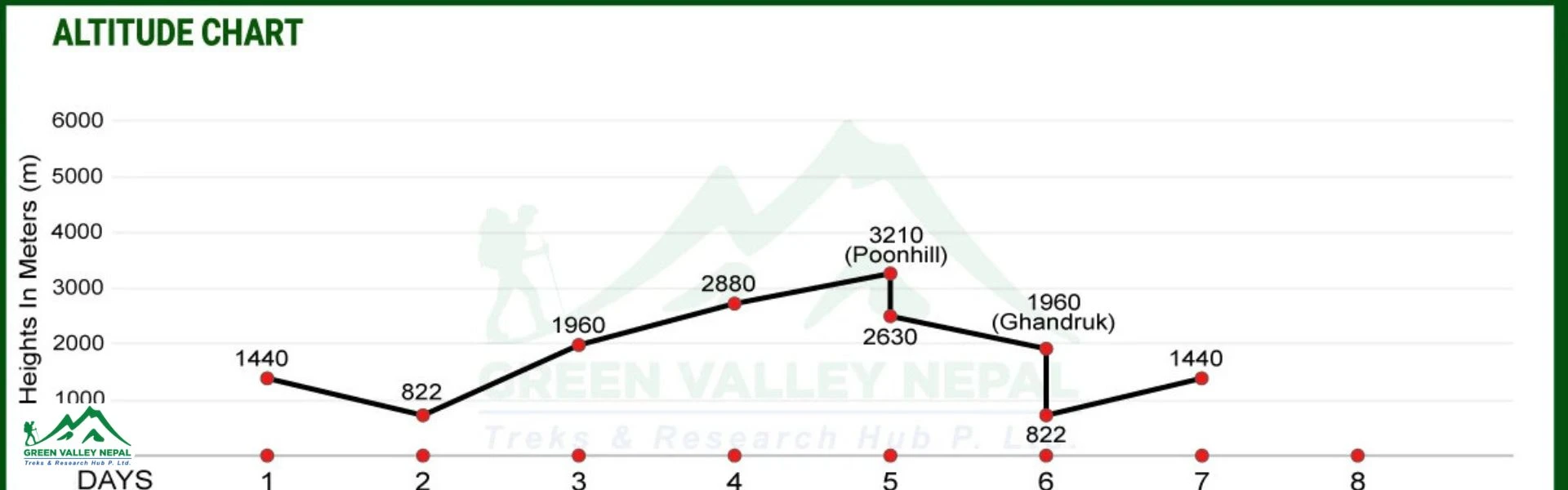
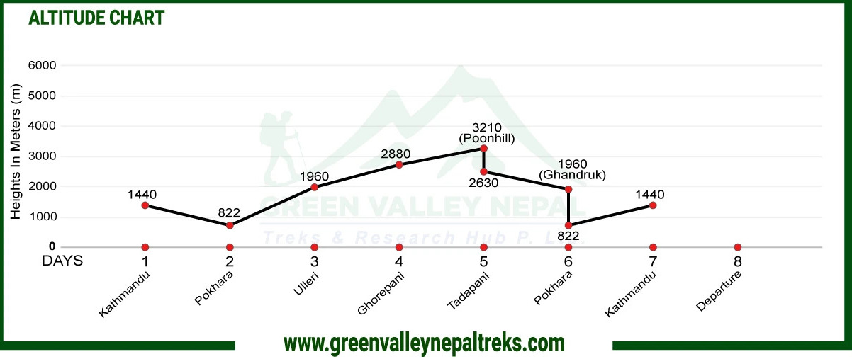
- Altitude profile chart: Day-by-day elevation gain
- Trail types: stone steps, forest trails, ridgelines
- Viewpoints: Poon Hill (3,210 m)
- Water sources & rivers
- Checkpoints & permit areas
- Alternative routes (Jhinu Danda, Banthanti, etc.)
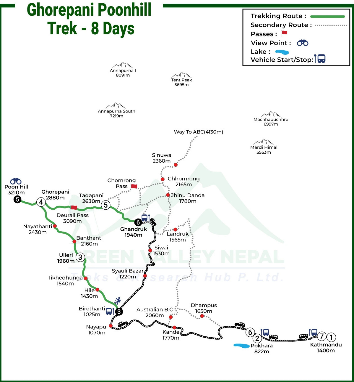
Route Breakdown with Ghorepani Poon Hill Trek Altitude Map Insights
Trekking Route | Distance (Kilometers) | Duration (Hours) | Altitude (Meters) | Elevation Gain/Loss |
Drive from Pokhara to Birethanti | 41.7 / 25.9 miles | 1 to 2 | 1263 / 4143 ft | +441 m |
Trek from Birethanti to Ulleri | 8.8 / 5.4 miles | 5 to 6 | 1960 / 6430 ft | +697 m |
Trek from Ulleri to Ghorepani | 10.3 / 6.4 miles | 4 to 5 | 2880 / 9448 ft | +920 m |
Trek from Ghorepani to Poon Hill, then to Tadapani | 11 / 6.8 miles | 5 to 6 | 3210 / 10,531 ft | +330 m |
Trek from Tadapani to Ghandruk | 6.5 / 4 miles | 3 to 4 | 1940 / 6364 ft | -1270 m |
Drive from Ghandruk to Pokhara | 42 / 26 miles | 3 to 4 | 822 / 2696 ft | -1118 m |
Drive from Pokhara to Kathmandu | 205 / 127 miles | 8 to 9 | 1400 / 4593 ft | +578 m |
Day 1: Pokhara (820 m) → Birethanti (1263 m) → Ulleri (1960 m)
- Distance: ~20 km
- Time: 10 hours
- Elevation Gain: +697 m
This is a gentle introduction to the trek with a steady but continuous ascent through villages and farmland. Although the altitude gain is moderate, the lack of flat sections can feel slightly tiring for beginners. It’s ideal for adjusting your pace and getting used to trekking conditions.
Day 2: Ulleri (1960 m) → Ghorepani (2880 m)
- Distance: ~12 km
- Time: 6–7 hours
- Elevation Gain: +920 m
The toughest day of the trek, marked by a steep climb of over 3,000 stone steps to Ulleri, followed by a long uphill forest trail. The altitude map shows a sharp rise here, reflecting the biggest elevation gain and the highest physical effort required.
Day 3: Ghorepani → Poon Hill (3,210 m) → Tadapani (2,610 m)
- Distance: ~10–11 km
- Time: 6–7 hours
- Elevation Gain/Loss: +336 m / -580 m
A short but steep early morning hike leads to Poon Hill for sunrise views, followed by a longer descent toward Tadapani. The altitude profile shows a peak and drop, making this a rewarding day with both scenic highlights and downhill trekking.
Day 4: Tadapani → Ghandruk (1,940 m)
- Distance: ~8–10 km
- Time: 3–4 hours
- Elevation Loss: -700 m
This is a mostly downhill trek through forest trails and traditional villages, offering a more relaxed walking experience. The descending altitude reduces physical strain but can put pressure on knees, especially on stone steps.
Day 5: Ghandruk → Nayapul → Pokhara
- Distance: ~10–12 km
- Time: 5–6 hours
A gradual descent through farmland and villages brings you back to Nayapul, completing the loop. This final stretch is easy to navigate but can feel long due to accumulated fatigue from previous days.
How to Read the Ghorepani Poon Hill Altitude Map?
Most users don’t know how to interpret trekking maps. Here’s how:
- Horizontal Axis (Distance)
The horizontal axis represents the trekking distance covered each day, helping you understand how far you will walk. It’s useful for estimating daily trekking time and planning rest breaks accordingly.
- Vertical Axis (Elevation)
The vertical axis shows changes in altitude, indicating how high or low you go during the trek. It helps you identify elevation gain or loss, which directly impacts difficulty and fatigue levels.
- Spikes = Difficult Sections
Sharp upward spikes on the map indicate steep climbs that require more effort and energy. For example, the climb from Tikhedhunga to Ghorepani is the hardest, while the Poon Hill hike is short but steep.
Flat or gently sloping sections on the map represent easier walking with minimal elevation change. Trails like Tadapani to Ghandruk feel more relaxed, allowing you to recover from earlier climbs.
Route Variations (Important Map-Level Detail)
Route | Maximum Altitude | Trek Duration | Trek Distance | Altitude Gain / Loss |
Classic Loop Route | 3,210 m (Poon Hill) | 4–6 days | 30–45 km | +2,100 m / -2,100 m |
Short Route (Ulleri Start) | 3,210 m | 3–4 days | 20–30 km | +1,800 m / -1,800 m |
Jhinu Danda Extension | 3,210 m | 5–6 days | 35–50 km | +2,200 m / -2,300 m |
Reverse Route | 3,210 m | 4–6 days | 30–45 km | +2,100 m / -2,100 m |
Classic Loop Route (Most Popular)
This is the standard route covering all major highlights, including Ghorepani and Poon Hill, with a balanced ascent and descent. It’s ideal for first-time trekkers as the altitude gain is gradual and the itinerary is well-paced.
Route: Nayapul → Ulleri → Ghorepani → Poon Hill → Tadapani → Ghandruk → Nayapul
Short Route (3–4 Days)
This variation starts from Ulleri, skipping the lower section to save time. While it reduces duration, the ascent becomes steeper and more physically demanding due to rapid altitude gain.
Route: Start from Ulleri (skip the first section)
Jhinu Danda Extension (Hot Springs Route)
This route diverts from Tadapani toward Jhinu Danda, where trekkers can enjoy natural hot springs. It adds an extra day but provides a relaxing break after days of continuous trekking.
Route: Tadapani → Jhinu → Natural hot springs
Reverse Route
Starting from Ghandruk and moving toward Ghorepani offers a quieter trekking experience with fewer crowds. The altitude gain feels more gradual, and the route provides a different scenic perspective.
Route: Ghandruk → Tadapani → Ghorepani → Poon Hill
Terrain Breakdown (Very Important for Users)
Section | Terrain Type | Difficulty |
Nayapul → Tikhedhunga | Dirt trail, villages | Easy |
Tikhedhunga → Ulleri | Stone steps | Hard |
Ulleri → Ghorepani | Forest trail | Moderate |
Ghorepani → Poon Hill | Steep uphill | Moderate |
Tadapani → Ghandruk | Forest descent | Easy |
Distance vs Elevation Reality (What Maps Don’t Tell You)
Even though:
- Distance = short (30–45 km)
The trek feels harder because:
- Steep stair climbs
- Continuous elevation gain
- Humidity in forests
Where Trekkers Struggle Most (Based on Route Map)
The climb to Ulleri is the most physically demanding part of the trek, with over 3,000 steep stone steps. The sudden altitude gain and continuous uphill can quickly drain energy if not paced properly.
- Early Morning Poon Hill Hike
This short but steep hike is done before sunrise in cold temperatures, making it feel more challenging than expected. The combination of darkness, altitude, and incline requires steady pacing and proper layering.
Extended downhill sections can be tough on the knees, especially on stone steps and uneven trails. While less tiring than climbing, they require careful footing and controlled movement to avoid strain or injury.
Permits & Checkpoints on the Ghorepani Poonhill Trek Route Map
While trekking the Ghorepani Poonhill route, you will pass through key checkpoints at Nayapul/Birethanti and the Ghorepani area, where local authorities monitor trekkers for safety and permit compliance.
To enter this beautiful region, all trekkers must obtain an ACAP (Annapurna Conservation Area Permit), which helps support conservation efforts and local communities. Additionally, a TIMS (Trekkers’ Information Management System) card is required, ensuring that trekkers are registered and tracked for safety purposes.
These permits are essential for a smooth and legal trekking experience. Both can be obtained in Pokhara or at the starting points of the trek, and it is advised to carry them at all times, as checkpoints may request to see them. Proper permits not only keep you safe but also contribute to the sustainable management of the Annapurna region.
Conclusion
The Ghorepani Poon Hill Trek Map is not just a visual guide; it’s a decision-making tool that helps trekkers understand distance, terrain, elevation, and difficulty before stepping onto the trail.
By analyzing the map properly, you can:
- Plan each trekking day efficiently
- Avoid unnecessary fatigue
- Choose the best route variation
- Trek safely with confidence
With its short duration, manageable altitude, and stunning Himalayan views, this trek remains one of the best beginner-friendly trekking routes in Nepal.
Frequently Asked Questions
- Is the 5-day Ghorepani Poonhill Trek suitable for beginners?
Yes, beginners can comfortably complete the 5-day Ghorepani Poonhill Trek. The path is clearly marked, and the itinerary is designed with a moderate pace, usually involving 4 to 6 hours of walking each day. With plenty of teahouses available for accommodation, it’s a great option for first-time trekkers who have a reasonable level of fitness.
- What is the highest point of the Ghorepani Poonhill Trek?
The trek’s highest elevation is reached at Poon Hill, which stands at 3,210 meters above sea level. This popular viewpoint is known for its stunning sunrise panoramas over the Annapurna and Dhaulagiri ranges.
- Can I do the Ghorepani Poonhill Trek without a guide?
Yes, it is possible to complete the trek independently since the route is well-established and signposted. However, hiring a guide can enhance your experience by providing local knowledge, ensuring smoother navigation, and assisting with logistics, especially for those new to trekking in Nepal.
- When is the ideal time to trek to Ghorepani Poonhill?
The most favorable seasons for this trek are spring (March to May) and autumn (September to November). During these months, the weather is generally stable, visibility is excellent, and the trails are especially beautiful with blooming rhododendrons in spring.
- Do I need an altitude chart for the Ghorepani Poonhill Trek?
Having an altitude chart is beneficial as it helps you monitor elevation changes throughout the trek. It also allows for better planning of your pace and rest, which can help minimize the chances of altitude sickness.
- Is an altitude chart necessary for the Ghorepani Poonhill Trek?
While not mandatory, an altitude chart is highly useful. It gives a clear understanding of daily elevation gain and supports proper pacing and acclimatization, reducing fatigue and the risk of altitude-related issues.
- What is the elevation of the Poon Hill viewpoint on the trek map?
Poon Hill is located at an elevation of 3,210 meters (10,531 feet), making it the highest point shown on the Ghorepani Poonhill trekking route.
- Which villages are included on the Ghorepani Poonhill trekking route?
The main villages along the route typically include Nayapul, Tikhedhunga, Ulleri, Ghorepani, Deurali, Tadapani, and Ghandruk. These stops are commonly indicated on trekking maps.
- Is Poon Hill within the Annapurna Conservation Area?
Yes, the entire trekking route to Ghorepani and Poon Hill lies inside the Annapurna Conservation Area, as reflected on official maps.
- Which route is best for sunrise views on the Ghorepani Poonhill Trek?
For the best sunrise experience, trekkers usually take the early morning hike from Ghorepani to Poon Hill. This well-marked trail takes around 45 minutes and offers spectacular views at dawn.