What Happened to the Langtang Trek Route?
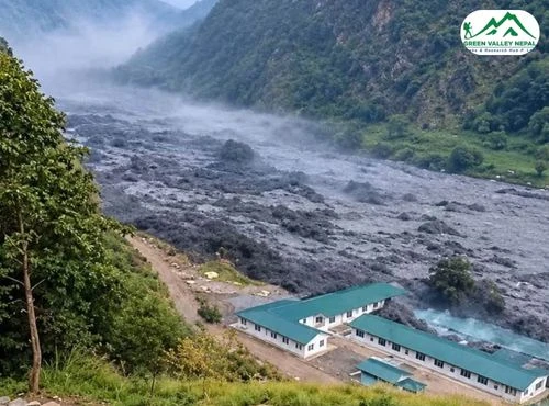
On 26 August 2026, a sudden flood came down the Bhote Koshi from the Tibetan side and damaged Timure and Syabrubesi, the roadhead for the Langtang Valley, Tamang Heritage and Ganja La treks. National reports counted more than 1,300 deaths by mid-September, and the exact trigger was still being investigated when we last checked. Our Bhotekoshi flood report covers the causes and damage. If you want to help affected families, see our Rasuwa flood donation appeal.
For trekkers, the important detail is where the damage sits. The flood followed the Bhote Koshi and Trishuli corridor. The Langtang Khola, which the trail to Kyanjin Gompa follows, is a separate river, and TAAN's advisory describes the valley as open. What failed was access: bridges and road sections between Betrawati and Syabrubesi, and the town itself. So the question is no longer "is Langtang closed?" but "which gateway do I use?"
Langtang Trek Status: What Is Open and What Is Not
The table below reflects TAAN's 22 October advisory and news reports up to 25 October 2026. Conditions change quickly, so always confirm with your operator before you travel.
Section | Status | Notes |
Kathmandu to Betrawati to Dhunche road | Open | A 73-metre Bailey bridge at Betrawati restored the Nuwakot to Rasuwa road link on 11 October. |
Dhunche to Thulo Syabru | Usable | Steep, unpaved road suited to 4WD vehicles; if closed, walking takes about 5 to 6 hours. |
Syabrubesi motorable bridge | Under construction | Authorities are building a replacement Bailey bridge, targeted before Tihar in early November. Treat vehicle access as unconfirmed until it opens. |
Syabrubesi footbridge | Temporary crossing in place | The Tamang Heritage and Ruby Valley trails reopened over a temporary bridge, per reports on 24 and 25 October. |
Bamboo, Lama Hotel, Langtang Village, Kyanjin Gompa | Open | Teahouse trekking reported running. TAAN calls the area safe for trekking. |
Helambu and Gosaikunda | Open | Used by TAAN's second route into Langtang. |
Syabrubesi vs Thulo Syabru: Avoiding a Common Mix-Up
Trekkers often confuse these two villages because the names are so close. They are different places.
Basis | Syabrubesi | Thulo Syabru |
Elevation | About 1,460 m | About 2,230 m |
Location | River valley, the old road-head | Ridge village above the Langtang Khola |
Flood impact | Heavily damaged | Not on the flood's path |
Role | Classic start of the Langtang Valley trek | Junction for Langtang Valley and Gosaikunda |
The classic trail from Syabrubesi and the ridge trail from Thulo Syabru both drop to the river and meet near Bamboo. From there, every trekker walks the same path to Lama Hotel, Langtang Village, and Kyanjin Gompa. Only the first day or two differ.
Langtang Valley Alternative Routes Compared
Route | Starts at | Reach Kyanjin on day | Total trip | Highest point | Difficulty | Best for | Status |
1. Dhunche and Thulo Syabru | Dhunche or Thulo Syabru | 4 | 8 days | 3,870 m (4,773 m on Kyanjin Ri) | Moderate | First-timers, limited time | Open per TAAN |
2. Helambu and Gosaikunda | Sundarijal or Chisapani | 9 | 11 to 13 days | 4,610 m | Moderate to strenuous | Fit trekkers with two weeks | Open per TAAN |
3. Talu and Gosaikunda | Dupcheshwor or Talu | 6 | 9 days | 4,610 m | Moderate to strenuous | Quiet trails, homestays | Operator-reported |
4. Tilman Pass | Chhimti and Panch Pokhari | 9 | 12 days | Above 5,000 m | Strenuous, camping | Experienced trekkers | Operator-reported |
Day counts treat the Kathmandu departure as day 1. Operators, rather than TAAN, describe routes 3 and 4, so ask us for the latest status before you commit.
Route 1: Drive to Dhunche or Thulo Syabru, Then Trek to Kyanjin (Best Overall Alternative)
This is the option TAAN lists first, and it is the closest to the classic Langtang itinerary. You skip Syabrubesi completely. Dhunche, the Rasuwa district headquarters, lies away from the Bhote Koshi corridor that took the worst of the flood, and Thulo Syabru sits on the ridge above the Langtang Khola.
How do you get there?
Kathmandu to Trishuli, Betrawati, and Dhunche is roughly 110 km and takes 6 to 7 hours, longer if landslides cause delays. From Dhunche, operators use a 4WD vehicle on the steep road toward Thulo Syabru. If that road is closed, walk from Dhunche via Thulo Bharkhu in about 5 to 6 hours, which usually adds one day.
8-day itinerary
Day | Route | Time | Sleep |
1 | Kathmandu to Thulo Syabru by 4WD (or to Dhunche if the upper road is shut) | 6 to 7 hours drive | Thulo Syabru, about 2,230 m |
2 | Thulo Syabru to Pairo, Bamboo and Lama Hotel | 6 to 7 hours | Lama Hotel, about 2,470 m |
3 | Lama Hotel to Ghoda Tabela and Langtang Village | 5 to 6 hours | Langtang Village, about 3,430 m |
4 | Langtang Village to Mundu, Sindum and Kyanjin Gompa | 3 to 4 hours | Kyanjin Gompa, about 3,870 m |
5 | Kyanjin Ri (4,773 m) or Tserko Ri (4,984 m) side hike, or rest | 3 to 7 hours | Kyanjin Gompa |
6 | Kyanjin Gompa to Lama Hotel | 5 to 6 hours | Lama Hotel |
7 | Lama Hotel to Thulo Syabru | 6 to 7 hours | Thulo Syabru |
8 | Thulo Syabru to Dhunche and Kathmandu | 6 to 7 hour drive | Kathmandu |
Pros
Shortest alternative, with the same valley scenery as the classic route.
Avoids Syabrubesi and the Bhote Koshi gorge.
Thulo Syabru has teahouses and is a junction, so you can extend to Gosaikunda if the weather and your legs allow.
Cons
Long first-day drive on a road that landslides can slow.
The Dhunche to Thulo Syabru road is steep and unpaved, so it suits only 4WD vehicles with experienced drivers.
Day 2 and day 7 each include a river descent and a stiff climb, which is hard on tired knees.
Best for: First-time Himalayan trekkers, and anyone with about a week. Our standard Langtang Valley Trek (10 days) is routed this way; ask us for the customized itinerary.
Route 2: Helambu, Gosaikunda and Thulo Syabru, Then Down Into Langtang (Most Scenic)
This is TAAN's second route. You start on foot from the Kathmandu Valley rim, walk through Hyolmo villages in Helambu, cross the Laurebina La pass, pass the sacred Gosaikunda lakes, and descend to Thulo Syabru before joining the Langtang trail. It never touches the damaged corridor.
11-day itinerary (helicopter return)
Day | Route | Time | Sleep |
1 | Kathmandu to Sundarijal, trek to Chisapani | 5 to 6 hours walk | Chisapani, about 2,215 m |
2 | Chisapani to Kutumsang | 7 to 8 hours | Kutumsang, about 2,470 m |
3 | Kutumsang to Tharepati (also spelled Thadepati) | 6 to 7 hours | About 3,600 m |
4 | Tharepati to Ghopte and Phedi | 5 to 6 hours | About 3,730 m |
5 | Phedi to Laurebina La (4,610 m) to Gosaikunda | 6 to 7 hours | Gosaikunda, about 4,380 m |
6 | Gosaikunda to Thulo Syabru | 6 to 7 hours | Thulo Syabru, about 2,230 m |
7 | Thulo Syabru to Lama Hotel | 5 to 7 hours | Lama Hotel, about 2,470 m |
8 | Lama Hotel to Langtang Village | 5 to 7 hours | About 3,430 m |
9 | Langtang Village to Kyanjin Gompa | 3 to 4 hours | About 3,870 m |
10 | Rest day or Kyanjin Ri hike | 3 to 5 hours | Kyanjin Gompa |
11 | Helicopter to Kathmandu, weather permitting | 35 to 45 minute flight | Kathmandu |
If you prefer to walk out, add two days: Kyanjin to Lama Hotel, then Thulo Syabru, then drive from Dhunche. That makes about 13 days in total.
Pros
Completely avoids the flood corridor and Syabrubesi.
Adds Helambu culture and the Gosaikunda lakes to one trip.
Quieter trails than the classic route.
Cons
Much longer and more strenuous: the pass is at 4,610 m on day 5.
The climb from Kutumsang to Tharepati gains over 1,000 m, so build in an extra night or rest day to acclimatize.
Needs a Shivapuri Nagarjun National Park permit in addition to the Langtang National Park permit.
Best for: Fit trekkers with about two weeks. Our Langtang Gosaikunda Lake Trek (15 days) covers this ground, and our Helambu Circuit Trek (8 days) is a gentler way to see the same villages.
Route 3: Dupcheshwor, Talu and Gosaikunda (Quiet Trail Option)
This route starts at Talu village, reached by road from Kathmandu via Dupcheshwor Mahadev. It is a shorter way to Gosaikunda than the Sundarijal route because you skip Helambu, so it suits trekkers with nine or ten days who still want a high-altitude crossing. This route is described by operators rather than in TAAN's advisory, so confirm its status with us before you commit.
Day 1: Drive Kathmandu to Talu village (6 to 7 hours, homestay).
Day 2: Trek Talu to Phedi (6 to 7 hours).
Day 3: Phedi to Laurebina La (4,610 m) and Gosaikunda (about 4,380 m).
Day 4: Gosaikunda to Thulo Syabru.
Days 5 to 6: Thulo Syabru to Lama Hotel and Langtang Village, then Kyanjin Gompa on the same trail as Route 2.
Days 7 to 9: Kyanjin hike or rest, return via Lama Hotel and Thulo Syabru, then drive to Kathmandu.
Best for: A fast gain in altitude on days 2 and 3. Ask your guide about an extra night at Phedi if anyone has headaches or poor sleep.
Route 4: Tilman Pass via Panch Pokhari (Experienced Trekkers Only)
This is a camping route over the Tilman Pass, which sits above 5,000 m, linking Panch Pokhari with the upper Langtang Valley near Langshisha Kharka and Kyanjin Gompa. Beyond Panch Pokhari, there are no teahouses until Kyanjin, so you need tents, a camping crew, and strong acclimatization. It takes about 12 days, with a rest day at Panch Pokhari.
Choose it only if you have already trekked at altitude, are comfortable with long camping days, and can join a properly equipped, guided team. Newcomers should choose Route 1.
Not a trek? Fly instead. If you have one day and want to see Langtang from the air, our Langtang helicopter tour from Kathmandu avoids the road entirely.
Which Alternative Route Should You Choose?
Your situation | Best choice |
First Himalayan trek, about a week | Route 1: Dhunche and Thulo Syabru |
Two weeks, good fitness, want lakes and culture | Route 2: Helambu and Gosaikunda |
Nine to ten days, want quieter trails | Route 3: Talu and Gosaikunda |
Experienced, comfortable camping above 5,000 m | Route 4: Tilman Pass |
Only one day | Langtang helicopter tour |
Unsure about Rasuwa this season | Helambu Circuit, Ama Yangri or another region |
Classic Route vs Alternative Routes: What Changes
Factor | Classic (via Syabrubesi) | Route 1 (Dhunche, Thulo Syabru) | Route 2 (Helambu, Gosaikunda) |
Gateway | Syabrubesi | Dhunche or Thulo Syabru | Sundarijal or Chisapani |
Drive from Kathmandu | 7 to 9 hours | 6 to 7 hours (4WD on the upper road) | About 1 hour to Sundarijal |
Reach Kyanjin on day | 4 | 4 | 9 |
Difficulty | Easy to moderate | Moderate | Moderate to strenuous |
Main risks | Damaged bridge and road | Landslides on the upper road | Altitude, long days, weather at the pass |
Altitude and Acclimatization on the Alternative Routes
Place | Approx. elevation |
Kathmandu | 1,400 meters |
Syabrubesi | 1,460 meters |
Dhunche | 1,950 meters |
Thulo Syabru | 2,230 meters |
Lama Hotel | 2,470 meters |
Langtang Village | 3,430 meters |
Kyanjin Gompa | 3,870 meters |
Gosaikunda | 4,380 meters |
Laurebina La | 4,610 meters |
Kyanjin Ri | 4,773 meters |
Tserko Ri | 4,984 meters |
Above 3,000 m, aim to raise your sleeping altitude by 300 to 500 m a day and take a rest day every three or four nights.
On Route 1, the biggest jump is from Lama Hotel to Langtang Village, about 960 m. Walk slowly and drink steadily.
On Routes 2 and 3, you reach 4,380 m at Gosaikunda early in the trip. Ask your guide about an extra night at Ghopte or Phedi.
Descend if a headache, nausea, or poor sleep gets worse. Never climb higher with worsening symptoms.
Avoid combining the Kyanjin Ri climb and the long descent to Lama Hotel in a single day. A second night at Kyanjin is safer.
What Does the Alternative Route Cost?
Prices depend on group size, season, and service level, so we quote each trip individually. Compared with the classic route, the alternatives usually change the cost in these ways:
Cost factor | Route 1 | Routes 2 and 3 |
Transport | Similar; a 4WD is needed on the upper road | Shorter road transfer; a helicopter return is an optional extra |
Trek days | Same, or one extra day | Three to five extra days |
Guide and porter | Same daily cost, possibly one extra day | Higher, because of the extra days |
Permits | Langtang National Park | Langtang National Park, plus Shivapuri Nagarjun National Park for Route 2 |
Safety buffer | One spare day recommended | A spare day and an acclimatization day recommended |
Best Time to Trek Langtang after the Flood
Autumn (late September to November): the classic season, with stable weather and clear views. This year it overlaps with repair work, so build in buffer days.
Winter (December to February): cold, with snow above Kyanjin. High passes such as Laurebina La can be snowbound, so Routes 2 to 4 are best left for autumn or spring.
Spring (March to May): rhododendron blooms in the lower valley and clear mornings.
Monsoon (June to August): not recommended. Landslides and swollen rivers add risk, and this region has just shown how quickly conditions can change.
See our guide to the best trekking seasons in Nepal for month-by-month detail.
Safety Checklist for Langtang Alternative Routes
Confirm road and bridge status two to three weeks before departure and again 48 hours before you leave.
Start drives early and avoid night driving on mountain roads.
Cross temporary bridges one person at a time and follow your guide's instructions.
Stay away from riverbanks and low ground, especially after rain.
Move quickly through landslide-prone slopes and never rest beneath them.
Carry cash, a power bank, and a paper copy of your guide's number. Phone coverage is patchy after the Rasuwa floods.
Check that your insurance covers trekking to your route's maximum altitude and emergency helicopter evacuation. Our travel insurance guide explains what to look for.
Keep at least one spare day in your plan for weather, road delays, or acclimatization.
Follow official updates from the National Disaster Risk Reduction and Management Authority, the Nepal Tourism Board and TAAN. The Home Ministry emergency line is 1234.
What to Pack and How to Prepare
Pack layers, because the forest at Lama Hotel is warm by day while Kyanjin drops below freezing at night. Our Nepal trekking packing list covers waterproofs, insulation, and footwear. If you are new to multi-day treks, start with our trekking training guide and check the Nepal visa rules before you book flights.
Other Treks near Langtang That Reopened
Green Valley Packages That Fit Each Route
Browse all Langtang region treks on our site.
How You Can Support Langtang's Recovery
Langtang's villages depend on trekking income. Visiting responsibly with a registered operator, hiring local guides and porters, and staying in local teahouses puts money where it is needed. If you cannot travel, our Rasuwa Bhotekoshi flood donation appeal explains how to give to the Prime Minister's Natural Disaster Relief Fund and other verified channels.
Final Thoughts: Is Langtang Still Worth Trekking?
Yes. The flood changed how you reach the valley, not what is in it. Kyanjin Gompa, Langtang Lirung, and the Tamang villages along the Langtang Khola are all still there, and TAAN lists the valley as open. Choose Route 1 if you want the most dependable plan, Route 2 if you want a longer, more scenic journey, and a different region if Rasuwa does not feel right this season.
Tell us your dates, group size, and fitness level, and we will check the latest road and bridge status before suggesting a route. Message us on WhatsApp at +977 9841 392186, use our contact page, or plan a tailor-made trip.
Frequently Asked Questions (FAQs)
Yes. TAAN's 22 October 2026 advisory lists Langtang, Kyanjin, and Gosaikunda as open. The classic road to Syabrubesi is still being repaired, so most groups start from Dhunche or Thulo Syabru. Conditions can change, so confirm with your operator before you travel.
Yes. Drive to Dhunche or Thulo Syabru and walk via Bamboo and Lama Hotel, or walk through Helambu and Gosaikunda. Both routes reach Kyanjin Gompa without using Syabrubesi.
For most trekkers, Route 1 from Dhunche or Thulo Syabru is best. It is the shortest, it follows the classic trail after day 1, and TAAN lists it as an open option. With two weeks and good fitness, Route 2 via Helambu and Gosaikunda is the most scenic.
Route 1 adds none, or one day if you must walk from Dhunche to Thulo Syabru. The Helambu and Gosaikunda route adds roughly three to five days compared with the classic itinerary.
No. Syabrubesi (about 1,460 m) is the flood-damaged road-head in the river valley. Thulo Syabru (about 2,230 m) is a ridge village and the junction for Langtang and Gosaikunda.
TAAN lists the area as open, but no mountain route is risk-free. Landslides on the upper road, temporary bridges, weather, and altitude are the main hazards. Travel with a registered agency and a licensed guide, and keep spare days in your plan.
We include a licensed guide in every itinerary. Nepal's guide rules have tightened since 2023, and sources differ on details, but after the flood, a guide who knows current bridges and trails is a sensible safety measure on any route.
You need a Langtang National Park entry permit and, where required, TIMS or e-TIMS. If you start from Sundarijal, you also need a Shivapuri Nagarjun National Park permit. We arrange all permits and confirm current fees at booking.
Reports on 24 and 25 October say the trail reopened via a temporary bridge at Syabrubesi. It starts near Syabrubesi, so it is a separate trek rather than an alternative way into Langtang. Confirm conditions before booking.
Yes. Our one-day Langtang helicopter tour flies from Kathmandu. Flights depend on weather and availability, so ask us whether a helicopter return from Kyanjin can be added to a trekking itinerary.
Route 1 from Dhunche or Thulo Syabru. It has the gentlest altitude profile, the shortest trip length, and the same teahouse trail as the classic Langtang itinerary.
Autumn (late September to November) and spring (March to May) are the best seasons. Build in buffer days this year because repair work on roads and bridges is still underway.
Travel responsibly with local guides and teahouses, or donate through verified channels. Our donation appeal lists ways to support the Prime Minister's Natural Disaster Relief Fund.